You are here: Home > Network List > TA - USArray Transportable Network (new EarthScope stations) Stations List
> Station E40A Wakefield, MI, USA > Earthquake Result Viewer
E40A Wakefield, MI, USA - Earthquake Result Viewer
| Earthquake location: |
Off East Coast Of Kamchatka |
| Earthquake latitude/longitude: |
52.4/160.3 |
| Earthquake time(UTC): |
2013/05/21 (141) 03:05:50 GMT |
| Earthquake Depth: |
11 km |
| Earthquake Magnitude: |
5.9 MW, 5.5 MB, 5.8 MS, 5.8 MW |
| Earthquake Catalog/Contributor: |
NEIC PDE/NEIC PDE-W |
|
| Network: |
TA USArray Transportable Network (new EarthScope stations) |
| Station: |
E40A Wakefield, MI, USA |
| Lat/Lon: |
46.44 N/89.90 W |
| Elevation: |
472 m |
|
| Distance: |
64.7 deg |
| Az: |
46.019 deg |
| Baz: |
320.38 deg |
| Ray Param: |
0.058748044 |
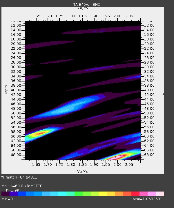
| Estimated Moho Depth: |
69.0 km |
| Estimated Crust Vp/Vs: |
1.99 |
| Assumed Crust Vp: |
6.467 km/s |
| Estimated Crust Vs: |
3.25 km/s |
| Estimated Crust Poisson's Ratio: |
0.33 |
|
| Radial Match: |
84.64811 % |
| Radial Bump: |
400 |
| Transverse Match: |
65.722206 % |
| Transverse Bump: |
400 |
| SOD ConfigId: |
512894 |
| Insert Time: |
2013-09-14 11:44:21.110 +0000 |
| GWidth: |
2.5 |
| Max Bumps: |
400 |
| Tol: |
0.001 |
|

Signal To Noise
| Channel | StoN | STA | LTA |
| TA:E40A: :BHZ:20130521T03:15:57.575005Z | 2.1024065 | 3.505344E-7 | 1.6673008E-7 |
| TA:E40A: :BHN:20130521T03:15:57.575005Z | 2.0311408 | 2.2750591E-7 | 1.1200892E-7 |
| TA:E40A: :BHE:20130521T03:15:57.575005Z | 1.4087563 | 1.4017415E-7 | 9.950206E-8 |
| Arrivals |
| Ps | 11 SECOND |
| PpPs | 31 SECOND |
| PsPs/PpSs | 42 SECOND |


