You are here: Home > Network List > TA - USArray Transportable Network (new EarthScope stations) Stations List
> Station I47A Gladwin, MI, USA > Earthquake Result Viewer
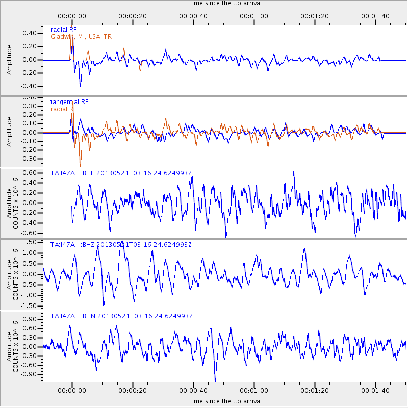
I47A Gladwin, MI, USA - Earthquake Result Viewer
*The percent match for this event was below the threshold and hence no stack was calculated.
| Earthquake location: |
Off East Coast Of Kamchatka |
| Earthquake latitude/longitude: |
52.4/160.3 |
| Earthquake time(UTC): |
2013/05/21 (141) 03:05:50 GMT |
| Earthquake Depth: |
11 km |
| Earthquake Magnitude: |
5.9 MW, 5.5 MB, 5.8 MS, 5.8 MW |
| Earthquake Catalog/Contributor: |
NEIC PDE/NEIC PDE-W |
|
| Network: |
TA USArray Transportable Network (new EarthScope stations) |
| Station: |
I47A Gladwin, MI, USA |
| Lat/Lon: |
44.02 N/84.51 W |
| Elevation: |
269 m |
|
| Distance: |
69.0 deg |
| Az: |
44.381 deg |
| Baz: |
323.551 deg |
| Ray Param: |
$rayparam |
*The percent match for this event was below the threshold and hence was not used in the summary stack. |
|
| Radial Match: |
66.3317 % |
| Radial Bump: |
400 |
| Transverse Match: |
49.048626 % |
| Transverse Bump: |
400 |
| SOD ConfigId: |
512894 |
| Insert Time: |
2013-09-14 11:46:06.782 +0000 |
| GWidth: |
2.5 |
| Max Bumps: |
400 |
| Tol: |
0.001 |
|
Signal To Noise
| Channel | StoN | STA | LTA |
| TA:I47A: :BHZ:20130521T03:16:24.624993Z | 2.79274 | 5.334672E-7 | 1.9101927E-7 |
| TA:I47A: :BHN:20130521T03:16:24.624993Z | 2.021763 | 3.1370516E-7 | 1.5516416E-7 |
| TA:I47A: :BHE:20130521T03:16:24.624993Z | 1.0809304 | 1.9821323E-7 | 1.833728E-7 |
| Arrivals |
| Ps | |
| PpPs | |
| PsPs/PpSs | |


