You are here: Home > Network List > TA - USArray Transportable Network (new EarthScope stations) Stations List
> Station L49A Milan, MI, USA > Earthquake Result Viewer
L49A Milan, MI, USA - Earthquake Result Viewer
| Earthquake location: |
Off East Coast Of Kamchatka |
| Earthquake latitude/longitude: |
52.4/160.3 |
| Earthquake time(UTC): |
2013/05/21 (141) 03:05:50 GMT |
| Earthquake Depth: |
11 km |
| Earthquake Magnitude: |
5.9 MW, 5.5 MB, 5.8 MS, 5.8 MW |
| Earthquake Catalog/Contributor: |
NEIC PDE/NEIC PDE-W |
|
| Network: |
TA USArray Transportable Network (new EarthScope stations) |
| Station: |
L49A Milan, MI, USA |
| Lat/Lon: |
42.11 N/83.77 W |
| Elevation: |
230 m |
|
| Distance: |
70.8 deg |
| Az: |
45.11 deg |
| Baz: |
324.307 deg |
| Ray Param: |
0.05472424 |
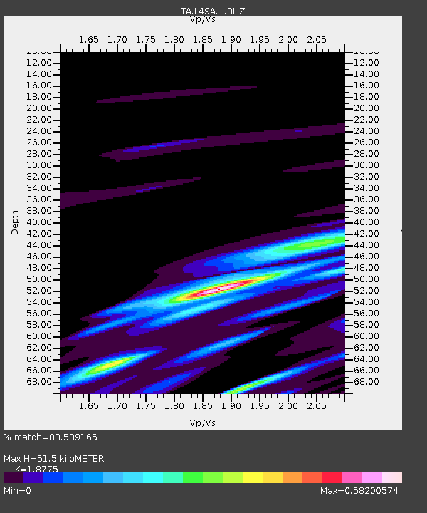
| Estimated Moho Depth: |
51.5 km |
| Estimated Crust Vp/Vs: |
1.88 |
| Assumed Crust Vp: |
6.483 km/s |
| Estimated Crust Vs: |
3.453 km/s |
| Estimated Crust Poisson's Ratio: |
0.30 |
|
| Radial Match: |
83.589165 % |
| Radial Bump: |
400 |
| Transverse Match: |
45.955105 % |
| Transverse Bump: |
398 |
| SOD ConfigId: |
512894 |
| Insert Time: |
2013-09-14 11:47:42.045 +0000 |
| GWidth: |
2.5 |
| Max Bumps: |
400 |
| Tol: |
0.001 |
|
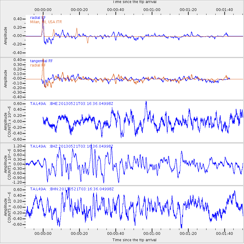
Signal To Noise
| Channel | StoN | STA | LTA |
| TA:L49A: :BHZ:20130521T03:16:36.04998Z | 2.4458601 | 4.884967E-7 | 1.9972389E-7 |
| TA:L49A: :BHN:20130521T03:16:36.04998Z | 0.9851122 | 1.8510687E-7 | 1.8790435E-7 |
| TA:L49A: :BHE:20130521T03:16:36.04998Z | 1.4060576 | 1.9553505E-7 | 1.3906617E-7 |
| Arrivals |
| Ps | 7.2 SECOND |
| PpPs | 22 SECOND |
| PsPs/PpSs | 29 SECOND |


