You are here: Home > Network List > TA - USArray Transportable Network (new EarthScope stations) Stations List
> Station V50A Pikevile, TN, USA > Earthquake Result Viewer
V50A Pikevile, TN, USA - Earthquake Result Viewer
| Earthquake location: |
Off East Coast Of Kamchatka |
| Earthquake latitude/longitude: |
52.4/160.3 |
| Earthquake time(UTC): |
2013/05/21 (141) 03:05:50 GMT |
| Earthquake Depth: |
11 km |
| Earthquake Magnitude: |
5.9 MW, 5.5 MB, 5.8 MS, 5.8 MW |
| Earthquake Catalog/Contributor: |
NEIC PDE/NEIC PDE-W |
|
| Network: |
TA USArray Transportable Network (new EarthScope stations) |
| Station: |
V50A Pikevile, TN, USA |
| Lat/Lon: |
35.67 N/85.10 W |
| Elevation: |
287 m |
|
| Distance: |
75.5 deg |
| Az: |
49.887 deg |
| Baz: |
324.86 deg |
| Ray Param: |
0.051650126 |
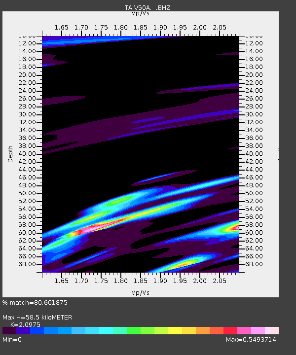
| Estimated Moho Depth: |
58.5 km |
| Estimated Crust Vp/Vs: |
2.10 |
| Assumed Crust Vp: |
6.35 km/s |
| Estimated Crust Vs: |
3.027 km/s |
| Estimated Crust Poisson's Ratio: |
0.35 |
|
| Radial Match: |
80.601875 % |
| Radial Bump: |
400 |
| Transverse Match: |
73.86887 % |
| Transverse Bump: |
400 |
| SOD ConfigId: |
512894 |
| Insert Time: |
2013-09-14 11:53:57.299 +0000 |
| GWidth: |
2.5 |
| Max Bumps: |
400 |
| Tol: |
0.001 |
|

Signal To Noise
| Channel | StoN | STA | LTA |
| TA:V50A: :BHZ:20130521T03:17:03.400017Z | 1.7075449 | 2.7251517E-7 | 1.5959472E-7 |
| TA:V50A: :BHN:20130521T03:17:03.400017Z | 1.6513213 | 2.8860106E-7 | 1.7476978E-7 |
| TA:V50A: :BHE:20130521T03:17:03.400017Z | 1.9775398 | 2.1110948E-7 | 1.0675359E-7 |
| Arrivals |
| Ps | 10 SECOND |
| PpPs | 28 SECOND |
| PsPs/PpSs | 38 SECOND |


