You are here: Home > Network List > UW - Pacific Northwest Regional Seismic Network Stations List
> Station MRBL Marblemount, WA, USA > Earthquake Result Viewer
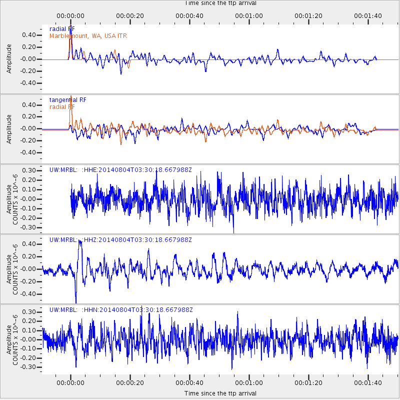
MRBL Marblemount, WA, USA - Earthquake Result Viewer
*The percent match for this event was below the threshold and hence no stack was calculated.
| Earthquake location: |
Near Coast Of Northern Peru |
| Earthquake latitude/longitude: |
-6.9/-81.6 |
| Earthquake time(UTC): |
2014/08/04 (216) 03:20:09 GMT |
| Earthquake Depth: |
23 km |
| Earthquake Magnitude: |
5.3 MW, 5.4 mb, 5.3 Mwb |
| Earthquake Catalog/Contributor: |
ISC/ISC |
|
| Network: |
UW Pacific Northwest Regional Seismic Network |
| Station: |
MRBL Marblemount, WA, USA |
| Lat/Lon: |
48.52 N/121.48 W |
| Elevation: |
75 m |
|
| Distance: |
65.3 deg |
| Az: |
332.027 deg |
| Baz: |
135.54 deg |
| Ray Param: |
$rayparam |
*The percent match for this event was below the threshold and hence was not used in the summary stack. |
|
| Radial Match: |
71.22687 % |
| Radial Bump: |
400 |
| Transverse Match: |
60.075092 % |
| Transverse Bump: |
400 |
| SOD ConfigId: |
3390531 |
| Insert Time: |
2019-04-13 05:08:54.548 +0000 |
| GWidth: |
2.5 |
| Max Bumps: |
400 |
| Tol: |
0.001 |
|
Signal To Noise
| Channel | StoN | STA | LTA |
| UW:MRBL: :HHZ:20140804T03:30:18.667988Z | 5.008699 | 2.5462063E-7 | 5.0835684E-8 |
| UW:MRBL: :HHN:20140804T03:30:18.667988Z | 1.5986896 | 1.1407095E-7 | 7.135279E-8 |
| UW:MRBL: :HHE:20140804T03:30:18.667988Z | 1.322828 | 1.03219215E-7 | 7.8029196E-8 |
| Arrivals |
| Ps | |
| PpPs | |
| PsPs/PpSs | |


