You are here: Home > Network List > TA - USArray Transportable Network (new EarthScope stations) Stations List
> Station L40A Anamosa, IA, USA > Earthquake Result Viewer
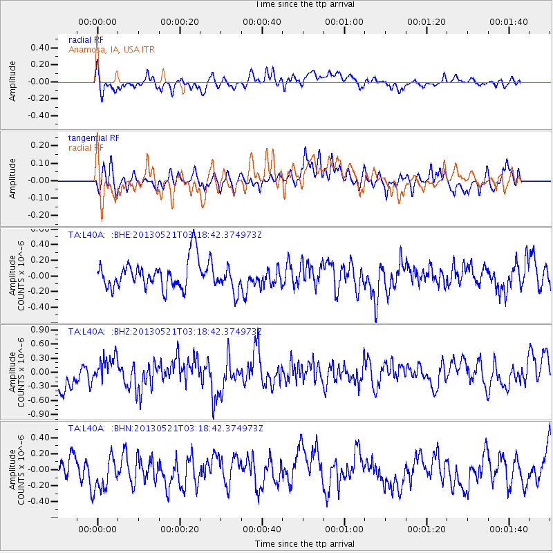
L40A Anamosa, IA, USA - Earthquake Result Viewer
*The percent match for this event was below the threshold and hence no stack was calculated.
| Earthquake location: |
Off East Coast Of Kamchatka |
| Earthquake latitude/longitude: |
52.5/160.1 |
| Earthquake time(UTC): |
2013/05/21 (141) 03:08:17 GMT |
| Earthquake Depth: |
7.6 km |
| Earthquake Magnitude: |
5.8 MW, 5.6 MB, 5.7 MW, 5.8 MS |
| Earthquake Catalog/Contributor: |
NEIC PDE/NEIC PDE-W |
|
| Network: |
TA USArray Transportable Network (new EarthScope stations) |
| Station: |
L40A Anamosa, IA, USA |
| Lat/Lon: |
42.06 N/91.22 W |
| Elevation: |
242 m |
|
| Distance: |
67.5 deg |
| Az: |
49.795 deg |
| Baz: |
321.165 deg |
| Ray Param: |
$rayparam |
*The percent match for this event was below the threshold and hence was not used in the summary stack. |
|
| Radial Match: |
48.237446 % |
| Radial Bump: |
400 |
| Transverse Match: |
55.091377 % |
| Transverse Bump: |
400 |
| SOD ConfigId: |
512894 |
| Insert Time: |
2013-09-14 12:27:31.884 +0000 |
| GWidth: |
2.5 |
| Max Bumps: |
400 |
| Tol: |
0.001 |
|
Signal To Noise
| Channel | StoN | STA | LTA |
| TA:L40A: :BHZ:20130521T03:18:42.374973Z | 0.9741542 | 2.836994E-7 | 2.9122637E-7 |
| TA:L40A: :BHN:20130521T03:18:42.374973Z | 1.1659173 | 2.589083E-7 | 2.2206405E-7 |
| TA:L40A: :BHE:20130521T03:18:42.374973Z | 0.9093532 | 1.6500515E-7 | 1.8145332E-7 |
| Arrivals |
| Ps | |
| PpPs | |
| PsPs/PpSs | |


