You are here: Home > Network List > TA - USArray Transportable Network (new EarthScope stations) Stations List
> Station L42A Oliver, Polo, IL, USA > Earthquake Result Viewer
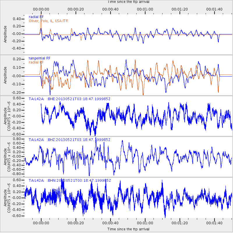
L42A Oliver, Polo, IL, USA - Earthquake Result Viewer
*The percent match for this event was below the threshold and hence no stack was calculated.
| Earthquake location: |
Off East Coast Of Kamchatka |
| Earthquake latitude/longitude: |
52.5/160.1 |
| Earthquake time(UTC): |
2013/05/21 (141) 03:08:17 GMT |
| Earthquake Depth: |
7.6 km |
| Earthquake Magnitude: |
5.8 MW, 5.6 MB, 5.7 MW, 5.8 MS |
| Earthquake Catalog/Contributor: |
NEIC PDE/NEIC PDE-W |
|
| Network: |
TA USArray Transportable Network (new EarthScope stations) |
| Station: |
L42A Oliver, Polo, IL, USA |
| Lat/Lon: |
42.00 N/89.67 W |
| Elevation: |
257 m |
|
| Distance: |
68.3 deg |
| Az: |
48.856 deg |
| Baz: |
321.849 deg |
| Ray Param: |
$rayparam |
*The percent match for this event was below the threshold and hence was not used in the summary stack. |
|
| Radial Match: |
54.392517 % |
| Radial Bump: |
400 |
| Transverse Match: |
46.91331 % |
| Transverse Bump: |
400 |
| SOD ConfigId: |
512894 |
| Insert Time: |
2013-09-14 12:27:34.307 +0000 |
| GWidth: |
2.5 |
| Max Bumps: |
400 |
| Tol: |
0.001 |
|
Signal To Noise
| Channel | StoN | STA | LTA |
| TA:L42A: :BHZ:20130521T03:18:47.199985Z | 1.1185155 | 2.8856783E-7 | 2.5799181E-7 |
| TA:L42A: :BHN:20130521T03:18:47.199985Z | 0.9020974 | 1.7761977E-7 | 1.9689645E-7 |
| TA:L42A: :BHE:20130521T03:18:47.199985Z | 1.9615008 | 3.4752273E-7 | 1.7717186E-7 |
| Arrivals |
| Ps | |
| PpPs | |
| PsPs/PpSs | |


