You are here: Home > Network List > CN - Canadian National Seismograph Network Stations List
> Station INK INUVIK, NT > Earthquake Result Viewer
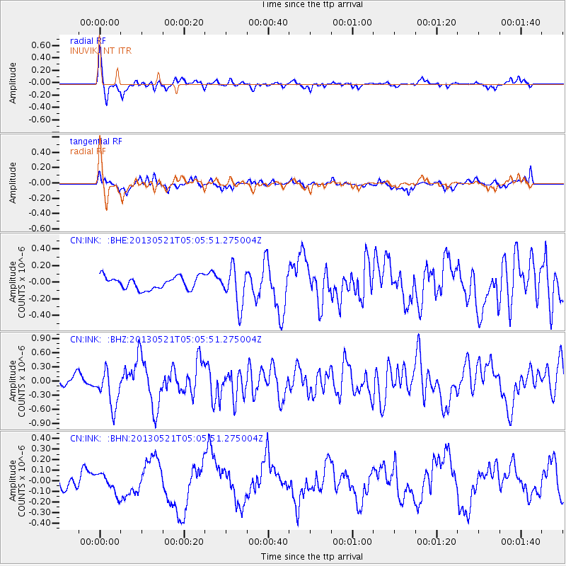
INK INUVIK, NT - Earthquake Result Viewer
*The percent match for this event was below the threshold and hence no stack was calculated.
| Earthquake location: |
Off East Coast Of Kamchatka |
| Earthquake latitude/longitude: |
52.3/160.1 |
| Earthquake time(UTC): |
2013/05/21 (141) 04:59:35 GMT |
| Earthquake Depth: |
18 km |
| Earthquake Magnitude: |
5.7 MW, 5.6 MS, 5.7 MW |
| Earthquake Catalog/Contributor: |
NEIC PDE/NEIC PDE-W |
|
| Network: |
CN Canadian National Seismograph Network |
| Station: |
INK INUVIK, NT |
| Lat/Lon: |
68.31 N/133.53 W |
| Elevation: |
44 m |
|
| Distance: |
34.5 deg |
| Az: |
37.01 deg |
| Baz: |
276.668 deg |
| Ray Param: |
$rayparam |
*The percent match for this event was below the threshold and hence was not used in the summary stack. |
|
| Radial Match: |
76.05094 % |
| Radial Bump: |
356 |
| Transverse Match: |
61.61542 % |
| Transverse Bump: |
400 |
| SOD ConfigId: |
512894 |
| Insert Time: |
2013-09-14 12:45:33.558 +0000 |
| GWidth: |
2.5 |
| Max Bumps: |
400 |
| Tol: |
0.001 |
|
Signal To Noise
| Channel | StoN | STA | LTA |
| CN:INK: :BHZ:20130521T05:05:51.275004Z | 4.472514 | 4.0313657E-7 | 9.013645E-8 |
| CN:INK: :BHN:20130521T05:05:51.275004Z | 0.93713945 | 9.483996E-8 | 1.0120154E-7 |
| CN:INK: :BHE:20130521T05:05:51.275004Z | 3.1374161 | 2.366482E-7 | 7.5427735E-8 |
| Arrivals |
| Ps | |
| PpPs | |
| PsPs/PpSs | |


