You are here: Home > Network List > TA - USArray Transportable Network (new EarthScope stations) Stations List
> Station R51A Hillsboro, KY, USA > Earthquake Result Viewer
R51A Hillsboro, KY, USA - Earthquake Result Viewer
| Earthquake location: |
Off East Coast Of Kamchatka |
| Earthquake latitude/longitude: |
52.3/160.1 |
| Earthquake time(UTC): |
2013/05/21 (141) 04:59:35 GMT |
| Earthquake Depth: |
18 km |
| Earthquake Magnitude: |
5.7 MW, 5.6 MS, 5.7 MW |
| Earthquake Catalog/Contributor: |
NEIC PDE/NEIC PDE-W |
|
| Network: |
TA USArray Transportable Network (new EarthScope stations) |
| Station: |
R51A Hillsboro, KY, USA |
| Lat/Lon: |
38.30 N/83.58 W |
| Elevation: |
231 m |
|
| Distance: |
74.1 deg |
| Az: |
47.13 deg |
| Baz: |
325.149 deg |
| Ray Param: |
0.052513912 |
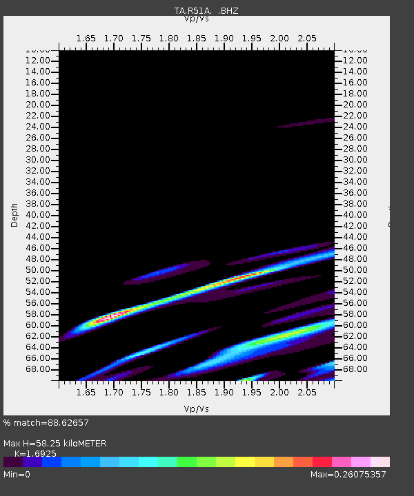
| Estimated Moho Depth: |
58.25 km |
| Estimated Crust Vp/Vs: |
1.69 |
| Assumed Crust Vp: |
6.232 km/s |
| Estimated Crust Vs: |
3.682 km/s |
| Estimated Crust Poisson's Ratio: |
0.23 |
|
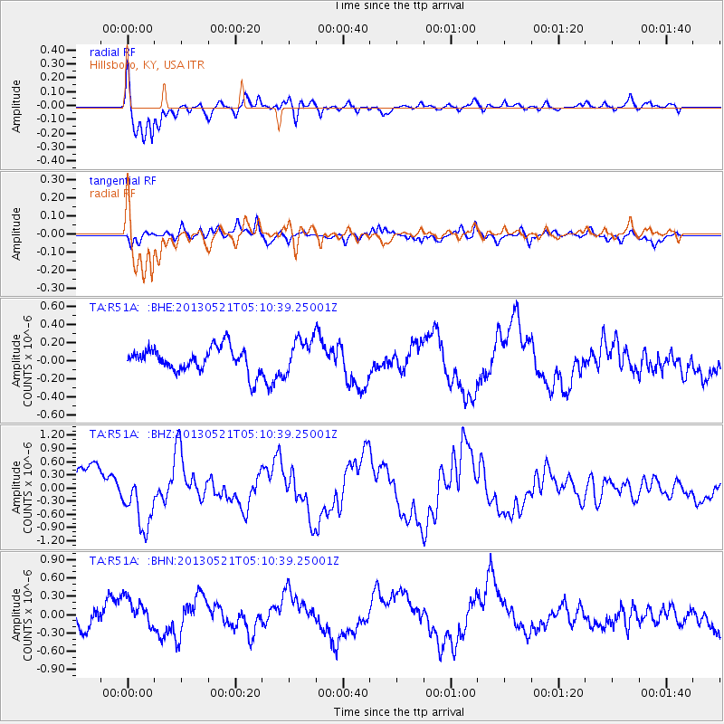
| Radial Match: |
88.62657 % |
| Radial Bump: |
364 |
| Transverse Match: |
45.3442 % |
| Transverse Bump: |
379 |
| SOD ConfigId: |
512894 |
| Insert Time: |
2013-09-14 13:11:39.238 +0000 |
| GWidth: |
2.5 |
| Max Bumps: |
400 |
| Tol: |
0.001 |
|
Signal To Noise
| Channel | StoN | STA | LTA |
| TA:R51A: :BHZ:20130521T05:10:39.25001Z | 2.2183735 | 6.83712E-7 | 3.0820416E-7 |
| TA:R51A: :BHN:20130521T05:10:39.25001Z | 1.6022774 | 2.4768394E-7 | 1.5458244E-7 |
| TA:R51A: :BHE:20130521T05:10:39.25001Z | 1.4259768 | 1.9424753E-7 | 1.3622069E-7 |
| Arrivals |
| Ps | 6.7 SECOND |
| PpPs | 24 SECOND |
| PsPs/PpSs | 31 SECOND |


