You are here: Home > Network List > US - United States National Seismic Network Stations List
> Station MIAR Mount Ida, Arkansas, USA > Earthquake Result Viewer
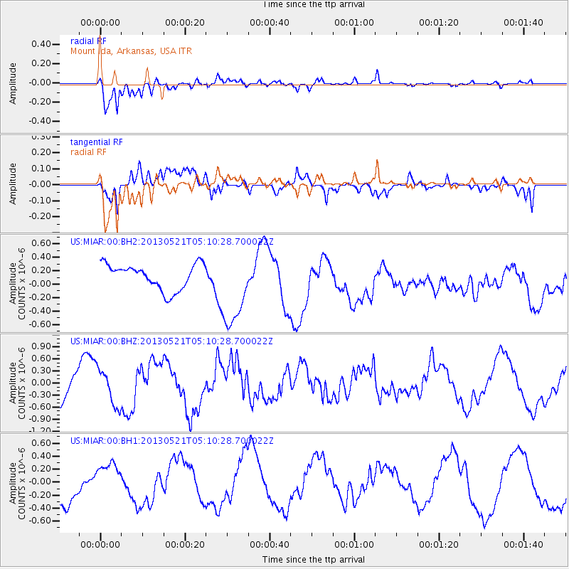
MIAR Mount Ida, Arkansas, USA - Earthquake Result Viewer
*The percent match for this event was below the threshold and hence no stack was calculated.
| Earthquake location: |
Off East Coast Of Kamchatka |
| Earthquake latitude/longitude: |
52.3/160.1 |
| Earthquake time(UTC): |
2013/05/21 (141) 04:59:35 GMT |
| Earthquake Depth: |
18 km |
| Earthquake Magnitude: |
5.7 MW, 5.6 MS, 5.7 MW |
| Earthquake Catalog/Contributor: |
NEIC PDE/NEIC PDE-W |
|
| Network: |
US United States National Seismic Network |
| Station: |
MIAR Mount Ida, Arkansas, USA |
| Lat/Lon: |
34.55 N/93.58 W |
| Elevation: |
207 m |
|
| Distance: |
72.4 deg |
| Az: |
56.215 deg |
| Baz: |
321.853 deg |
| Ray Param: |
$rayparam |
*The percent match for this event was below the threshold and hence was not used in the summary stack. |
|
| Radial Match: |
93.51131 % |
| Radial Bump: |
327 |
| Transverse Match: |
54.04391 % |
| Transverse Bump: |
400 |
| SOD ConfigId: |
512894 |
| Insert Time: |
2013-09-14 13:17:10.377 +0000 |
| GWidth: |
2.5 |
| Max Bumps: |
400 |
| Tol: |
0.001 |
|
Signal To Noise
| Channel | StoN | STA | LTA |
| US:MIAR:00:BHZ:20130521T05:10:28.700022Z | 0.9003466 | 4.4538507E-7 | 4.946818E-7 |
| US:MIAR:00:BH1:20130521T05:10:28.700022Z | 0.8069924 | 2.486747E-7 | 3.0815E-7 |
| US:MIAR:00:BH2:20130521T05:10:28.700022Z | 3.1160696 | 5.829207E-7 | 1.8706922E-7 |
| Arrivals |
| Ps | |
| PpPs | |
| PsPs/PpSs | |


