You are here: Home > Network List > PS - Pacific21 Stations List
> Station TSK Tsukuba, Japan > Earthquake Result Viewer
TSK Tsukuba, Japan - Earthquake Result Viewer
| Earthquake location: |
Santa Cruz Islands |
| Earthquake latitude/longitude: |
-11.0/166.2 |
| Earthquake time(UTC): |
1998/07/16 (197) 11:56:36 GMT |
| Earthquake Depth: |
110 km |
| Earthquake Magnitude: |
6.4 MB, 6.7 MS, 7.1 UNKNOWN, 6.9 ME |
| Earthquake Catalog/Contributor: |
WHDF/NEIC |
|
| Network: |
PS Pacific21 |
| Station: |
TSK Tsukuba, Japan |
| Lat/Lon: |
36.21 N/140.11 E |
| Elevation: |
350 m |
|
| Distance: |
53.0 deg |
| Az: |
333.606 deg |
| Baz: |
147.341 deg |
| Ray Param: |
0.06601373 |
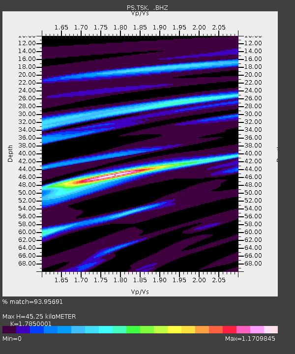
| Estimated Moho Depth: |
45.25 km |
| Estimated Crust Vp/Vs: |
1.79 |
| Assumed Crust Vp: |
6.24 km/s |
| Estimated Crust Vs: |
3.496 km/s |
| Estimated Crust Poisson's Ratio: |
0.27 |
|
| Radial Match: |
93.95691 % |
| Radial Bump: |
400 |
| Transverse Match: |
86.858864 % |
| Transverse Bump: |
400 |
| SOD ConfigId: |
4480 |
| Insert Time: |
2010-02-27 03:46:31.739 +0000 |
| GWidth: |
2.5 |
| Max Bumps: |
400 |
| Tol: |
0.001 |
|

Signal To Noise
| Channel | StoN | STA | LTA |
| PS:TSK: :BHZ:19980716T12:05:11.504004Z | 58.484863 | 1.1518673E-5 | 1.9695136E-7 |
| PS:TSK: :BHN:19980716T12:05:11.504004Z | 28.718391 | 5.067239E-6 | 1.7644578E-7 |
| PS:TSK: :BHE:19980716T12:05:11.504004Z | 11.075878 | 1.5935423E-6 | 1.4387503E-7 |
| Arrivals |
| Ps | 6.0 SECOND |
| PpPs | 19 SECOND |
| PsPs/PpSs | 25 SECOND |


