You are here: Home > Network List > PS - Pacific21 Stations List
> Station TSK Tsukuba, Japan > Earthquake Result Viewer
TSK Tsukuba, Japan - Earthquake Result Viewer
| Earthquake location: |
Mindanao, Philippines |
| Earthquake latitude/longitude: |
5.4/126.8 |
| Earthquake time(UTC): |
1998/09/02 (245) 08:37:29 GMT |
| Earthquake Depth: |
50 km |
| Earthquake Magnitude: |
6.6 MB, 6.7 MS, 6.8 UNKNOWN, 6.8 ME |
| Earthquake Catalog/Contributor: |
WHDF/NEIC |
|
| Network: |
PS Pacific21 |
| Station: |
TSK Tsukuba, Japan |
| Lat/Lon: |
36.21 N/140.11 E |
| Elevation: |
350 m |
|
| Distance: |
33.0 deg |
| Az: |
20.036 deg |
| Baz: |
204.947 deg |
| Ray Param: |
0.07829249 |
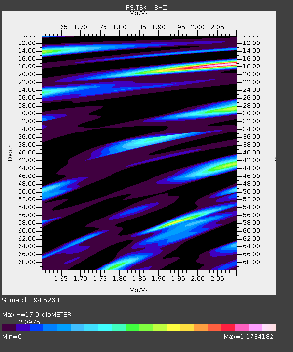
| Estimated Moho Depth: |
17.0 km |
| Estimated Crust Vp/Vs: |
2.10 |
| Assumed Crust Vp: |
6.24 km/s |
| Estimated Crust Vs: |
2.975 km/s |
| Estimated Crust Poisson's Ratio: |
0.35 |
|
| Radial Match: |
94.5263 % |
| Radial Bump: |
313 |
| Transverse Match: |
56.06298 % |
| Transverse Bump: |
400 |
| SOD ConfigId: |
4480 |
| Insert Time: |
2010-02-27 03:46:35.831 +0000 |
| GWidth: |
2.5 |
| Max Bumps: |
400 |
| Tol: |
0.001 |
|

Signal To Noise
| Channel | StoN | STA | LTA |
| PS:TSK: :BHZ:19980902T08:43:30.053015Z | 1.7947415 | 1.7163417E-6 | 9.56317E-7 |
| PS:TSK: :BHN:19980902T08:43:30.053015Z | 3.0772853 | 1.1105116E-6 | 3.6087377E-7 |
| PS:TSK: :BHE:19980902T08:43:30.053015Z | 1.5346273 | 8.8539235E-7 | 5.769429E-7 |
| Arrivals |
| Ps | 3.2 SECOND |
| PpPs | 7.9 SECOND |
| PsPs/PpSs | 11 SECOND |


