You are here: Home > Network List > PS - Pacific21 Stations List
> Station TSK Tsukuba, Japan > Earthquake Result Viewer
TSK Tsukuba, Japan - Earthquake Result Viewer

| Earthquake location: |
Fiji Islands Region |
| Earthquake latitude/longitude: |
-21.6/-176.5 |
| Earthquake time(UTC): |
1998/11/15 (319) 02:44:12 GMT |
| Earthquake Depth: |
149 km |
| Earthquake Magnitude: |
5.9 MB, 6.3 UNKNOWN, 6.2 MW |
| Earthquake Catalog/Contributor: |
WHDF/NEIC |
|
| Network: |
PS Pacific21 |
| Station: |
TSK Tsukuba, Japan |
| Lat/Lon: |
36.21 N/140.11 E |
| Elevation: |
350 m |
|
| Distance: |
70.6 deg |
| Az: |
323.921 deg |
| Baz: |
137.336 deg |
| Ray Param: |
0.05447039 |
| Estimated Moho Depth: |
24.5 km |
| Estimated Crust Vp/Vs: |
2.10 |
| Assumed Crust Vp: |
6.24 km/s |
| Estimated Crust Vs: |
2.975 km/s |
| Estimated Crust Poisson's Ratio: |
0.35 |
|
| Radial Match: |
83.59347 % |
| Radial Bump: |
400 |
| Transverse Match: |
72.18818 % |
| Transverse Bump: |
400 |
| SOD ConfigId: |
4480 |
| Insert Time: |
2010-02-27 03:46:37.007 +0000 |
| GWidth: |
2.5 |
| Max Bumps: |
400 |
| Tol: |
0.001 |
|
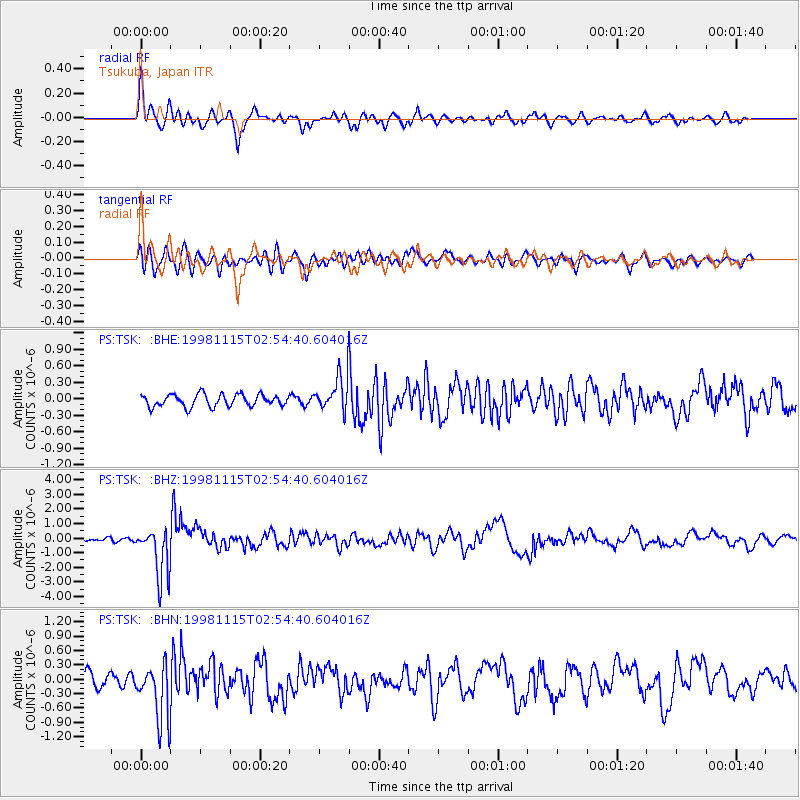
Signal To Noise
| Channel | StoN | STA | LTA |
| PS:TSK: :BHZ:19981115T02:54:40.604016Z | 12.301596 | 1.7237819E-6 | 1.401267E-7 |
| PS:TSK: :BHN:19981115T02:54:40.604016Z | 4.067377 | 5.9562905E-7 | 1.4644057E-7 |
| PS:TSK: :BHE:19981115T02:54:40.604016Z | 2.7724159 | 3.0816213E-7 | 1.1115292E-7 |
| Arrivals |
| Ps | 4.4 SECOND |
| PpPs | 12 SECOND |
| PsPs/PpSs | 16 SECOND |


