You are here: Home > Network List > PS - Pacific21 Stations List
> Station TSK Tsukuba, Japan > Earthquake Result Viewer
TSK Tsukuba, Japan - Earthquake Result Viewer

| Earthquake location: |
Pakistan |
| Earthquake latitude/longitude: |
30.0/68.2 |
| Earthquake time(UTC): |
1997/02/27 (058) 21:08:02 GMT |
| Earthquake Depth: |
33 km |
| Earthquake Magnitude: |
6.3 MB, 7.3 MS, 7.1 UNKNOWN, 6.6 ME |
| Earthquake Catalog/Contributor: |
WHDF/NEIC |
|
| Network: |
PS Pacific21 |
| Station: |
TSK Tsukuba, Japan |
| Lat/Lon: |
36.21 N/140.11 E |
| Elevation: |
350 m |
|
| Distance: |
59.3 deg |
| Az: |
63.37 deg |
| Baz: |
286.449 deg |
| Ray Param: |
0.062215034 |
| Estimated Moho Depth: |
20.75 km |
| Estimated Crust Vp/Vs: |
2.01 |
| Assumed Crust Vp: |
6.24 km/s |
| Estimated Crust Vs: |
3.101 km/s |
| Estimated Crust Poisson's Ratio: |
0.34 |
|
| Radial Match: |
94.6773 % |
| Radial Bump: |
400 |
| Transverse Match: |
87.87784 % |
| Transverse Bump: |
400 |
| SOD ConfigId: |
4480 |
| Insert Time: |
2010-02-27 03:46:42.000 +0000 |
| GWidth: |
2.5 |
| Max Bumps: |
400 |
| Tol: |
0.001 |
|
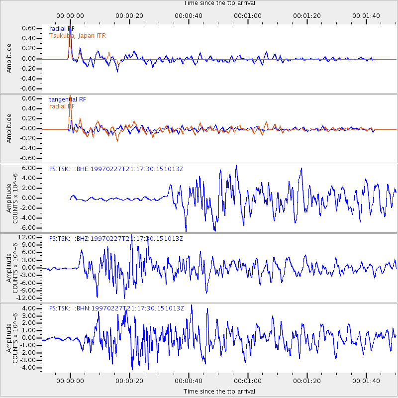
Signal To Noise
| Channel | StoN | STA | LTA |
| PS:TSK: :BHZ:19970227T21:17:30.151013Z | 9.976323 | 2.7070114E-6 | 2.713436E-7 |
| PS:TSK: :BHN:19970227T21:17:30.151013Z | 2.41295 | 5.805612E-7 | 2.4060225E-7 |
| PS:TSK: :BHE:19970227T21:17:30.151013Z | 5.124247 | 1.1883349E-6 | 2.3190428E-7 |
| Arrivals |
| Ps | 3.5 SECOND |
| PpPs | 9.6 SECOND |
| PsPs/PpSs | 13 SECOND |


