You are here: Home > Network List > PS - Pacific21 Stations List
> Station TSK Tsukuba, Japan > Earthquake Result Viewer
TSK Tsukuba, Japan - Earthquake Result Viewer
| Earthquake location: |
Santa Cruz Islands |
| Earthquake latitude/longitude: |
-11.3/165.4 |
| Earthquake time(UTC): |
2000/05/06 (127) 13:44:13 GMT |
| Earthquake Depth: |
12 km |
| Earthquake Magnitude: |
6.0 MB, 6.3 MS, 6.3 MW, 5.8 ME |
| Earthquake Catalog/Contributor: |
WHDF/NEIC |
|
| Network: |
PS Pacific21 |
| Station: |
TSK Tsukuba, Japan |
| Lat/Lon: |
36.21 N/140.11 E |
| Elevation: |
350 m |
|
| Distance: |
52.9 deg |
| Az: |
334.314 deg |
| Baz: |
148.285 deg |
| Ray Param: |
0.066426165 |
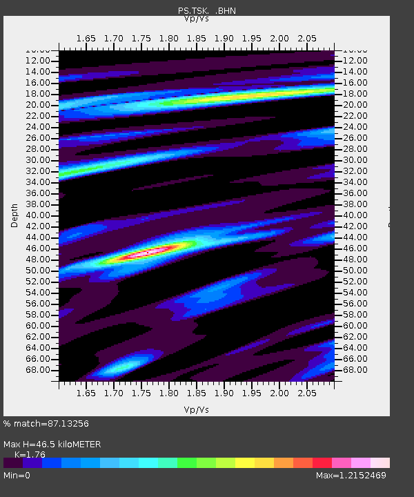
| Estimated Moho Depth: |
46.5 km |
| Estimated Crust Vp/Vs: |
1.76 |
| Assumed Crust Vp: |
6.24 km/s |
| Estimated Crust Vs: |
3.545 km/s |
| Estimated Crust Poisson's Ratio: |
0.26 |
|
| Radial Match: |
87.13256 % |
| Radial Bump: |
400 |
| Transverse Match: |
82.50813 % |
| Transverse Bump: |
400 |
| SOD ConfigId: |
3744 |
| Insert Time: |
2010-02-27 03:46:57.869 +0000 |
| GWidth: |
2.5 |
| Max Bumps: |
400 |
| Tol: |
0.001 |
|

Signal To Noise
| Channel | StoN | STA | LTA |
| PS:TSK: :BHN:20000506T13:52:58.952021Z | 2.9621844 | 4.3904686E-7 | 1.4821727E-7 |
| PS:TSK: :BHE:20000506T13:52:58.952021Z | 0.64067775 | 1.4215054E-7 | 2.2187525E-7 |
| PS:TSK: :BHZ:20000506T13:52:58.952021Z | 2.710887 | 9.253775E-7 | 3.4135599E-7 |
| Arrivals |
| Ps | 6.0 SECOND |
| PpPs | 20 SECOND |
| PsPs/PpSs | 25 SECOND |


