You are here: Home > Network List > TA - USArray Transportable Network (new EarthScope stations) Stations List
> Station G42A Mountain, WI, USA > Earthquake Result Viewer
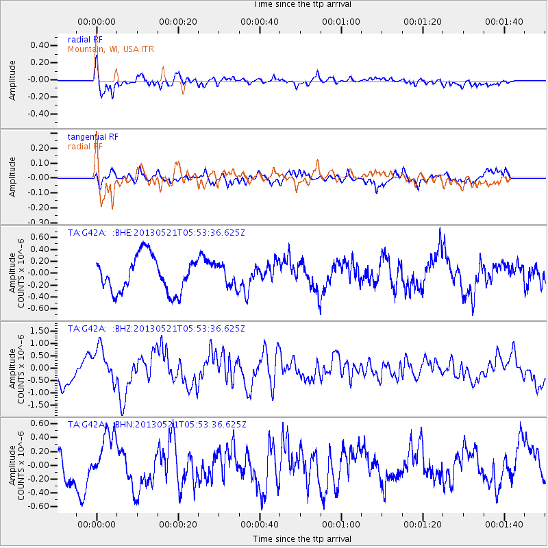
G42A Mountain, WI, USA - Earthquake Result Viewer
*The percent match for this event was below the threshold and hence no stack was calculated.
| Earthquake location: |
Off East Coast Of Kamchatka |
| Earthquake latitude/longitude: |
52.3/160.1 |
| Earthquake time(UTC): |
2013/05/21 (141) 05:43:21 GMT |
| Earthquake Depth: |
30 km |
| Earthquake Magnitude: |
6.1 MW, 5.8 MB, 6.1 MS, 6.1 MW |
| Earthquake Catalog/Contributor: |
NEIC PDE/NEIC PDE-W |
|
| Network: |
TA USArray Transportable Network (new EarthScope stations) |
| Station: |
G42A Mountain, WI, USA |
| Lat/Lon: |
45.24 N/88.43 W |
| Elevation: |
315 m |
|
| Distance: |
66.5 deg |
| Az: |
45.806 deg |
| Baz: |
321.429 deg |
| Ray Param: |
$rayparam |
*The percent match for this event was below the threshold and hence was not used in the summary stack. |
|
| Radial Match: |
72.364265 % |
| Radial Bump: |
400 |
| Transverse Match: |
52.60044 % |
| Transverse Bump: |
371 |
| SOD ConfigId: |
512894 |
| Insert Time: |
2013-09-14 13:46:30.411 +0000 |
| GWidth: |
2.5 |
| Max Bumps: |
400 |
| Tol: |
0.001 |
|
Signal To Noise
| Channel | StoN | STA | LTA |
| TA:G42A: :BHZ:20130521T05:53:36.625Z | 1.9359537 | 7.2121554E-7 | 3.7253756E-7 |
| TA:G42A: :BHN:20130521T05:53:36.625Z | 2.393975 | 3.7809153E-7 | 1.5793462E-7 |
| TA:G42A: :BHE:20130521T05:53:36.625Z | 0.6261168 | 1.8362363E-7 | 2.9327376E-7 |
| Arrivals |
| Ps | |
| PpPs | |
| PsPs/PpSs | |


