You are here: Home > Network List > TA - USArray Transportable Network (new EarthScope stations) Stations List
> Station K46A Dorr, MI, USA > Earthquake Result Viewer
K46A Dorr, MI, USA - Earthquake Result Viewer
| Earthquake location: |
Off East Coast Of Kamchatka |
| Earthquake latitude/longitude: |
52.3/160.1 |
| Earthquake time(UTC): |
2013/05/21 (141) 05:43:21 GMT |
| Earthquake Depth: |
30 km |
| Earthquake Magnitude: |
6.1 MW, 5.8 MB, 6.1 MS, 6.1 MW |
| Earthquake Catalog/Contributor: |
NEIC PDE/NEIC PDE-W |
|
| Network: |
TA USArray Transportable Network (new EarthScope stations) |
| Station: |
K46A Dorr, MI, USA |
| Lat/Lon: |
42.69 N/85.78 W |
| Elevation: |
213 m |
|
| Distance: |
69.7 deg |
| Az: |
45.858 deg |
| Baz: |
323.279 deg |
| Ray Param: |
0.05546085 |
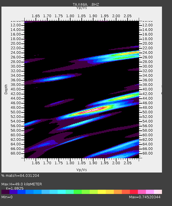
| Estimated Moho Depth: |
49.0 km |
| Estimated Crust Vp/Vs: |
1.89 |
| Assumed Crust Vp: |
6.483 km/s |
| Estimated Crust Vs: |
3.425 km/s |
| Estimated Crust Poisson's Ratio: |
0.31 |
|
| Radial Match: |
84.031204 % |
| Radial Bump: |
400 |
| Transverse Match: |
79.028435 % |
| Transverse Bump: |
400 |
| SOD ConfigId: |
512894 |
| Insert Time: |
2013-09-14 13:48:21.175 +0000 |
| GWidth: |
2.5 |
| Max Bumps: |
400 |
| Tol: |
0.001 |
|
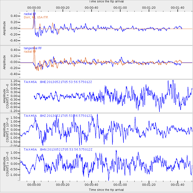
Signal To Noise
| Channel | StoN | STA | LTA |
| TA:K46A: :BHZ:20130521T05:53:56.575012Z | 2.4038475 | 7.931571E-7 | 3.2995317E-7 |
| TA:K46A: :BHN:20130521T05:53:56.575012Z | 2.1263857 | 4.784413E-7 | 2.250021E-7 |
| TA:K46A: :BHE:20130521T05:53:56.575012Z | 1.0806295 | 1.71375E-7 | 1.5858812E-7 |
| Arrivals |
| Ps | 7.0 SECOND |
| PpPs | 21 SECOND |
| PsPs/PpSs | 28 SECOND |


