You are here: Home > Network List > TA - USArray Transportable Network (new EarthScope stations) Stations List
> Station L39A Vinton, IA, USA > Earthquake Result Viewer
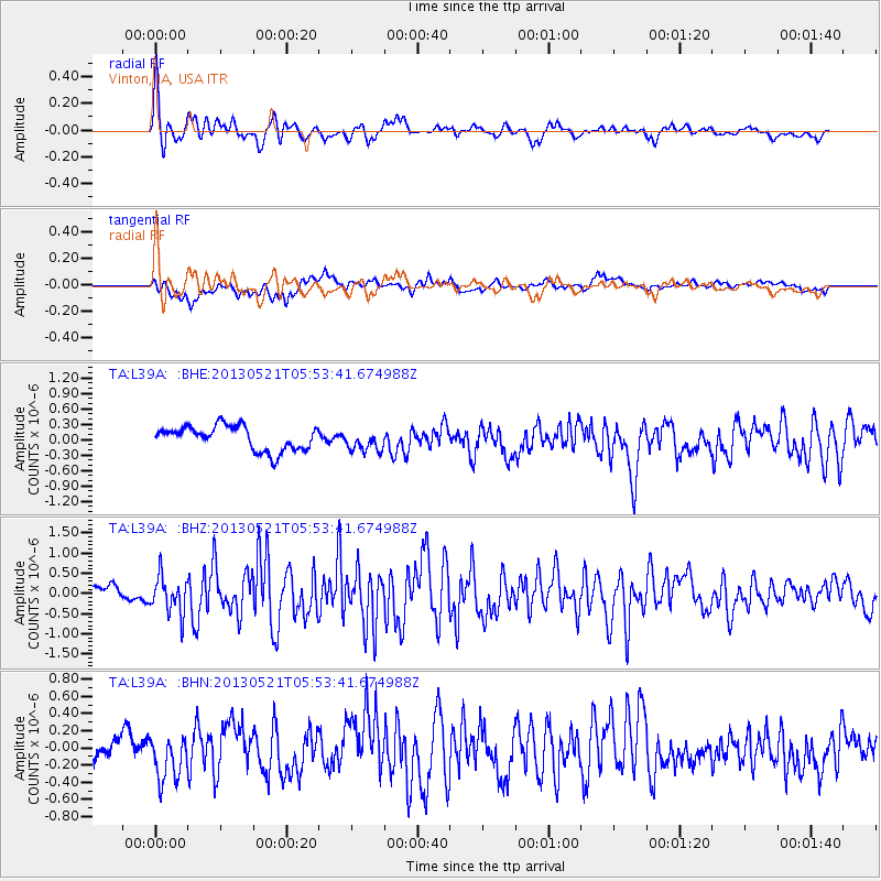
L39A Vinton, IA, USA - Earthquake Result Viewer
| Earthquake location: |
Off East Coast Of Kamchatka |
| Earthquake latitude/longitude: |
52.3/160.1 |
| Earthquake time(UTC): |
2013/05/21 (141) 05:43:21 GMT |
| Earthquake Depth: |
30 km |
| Earthquake Magnitude: |
6.1 MW, 5.8 MB, 6.1 MS, 6.1 MW |
| Earthquake Catalog/Contributor: |
NEIC PDE/NEIC PDE-W |
|
| Network: |
TA USArray Transportable Network (new EarthScope stations) |
| Station: |
L39A Vinton, IA, USA |
| Lat/Lon: |
42.12 N/92.00 W |
| Elevation: |
261 m |
|
| Distance: |
67.3 deg |
| Az: |
50.129 deg |
| Baz: |
320.668 deg |
| Ray Param: |
0.057029516 |
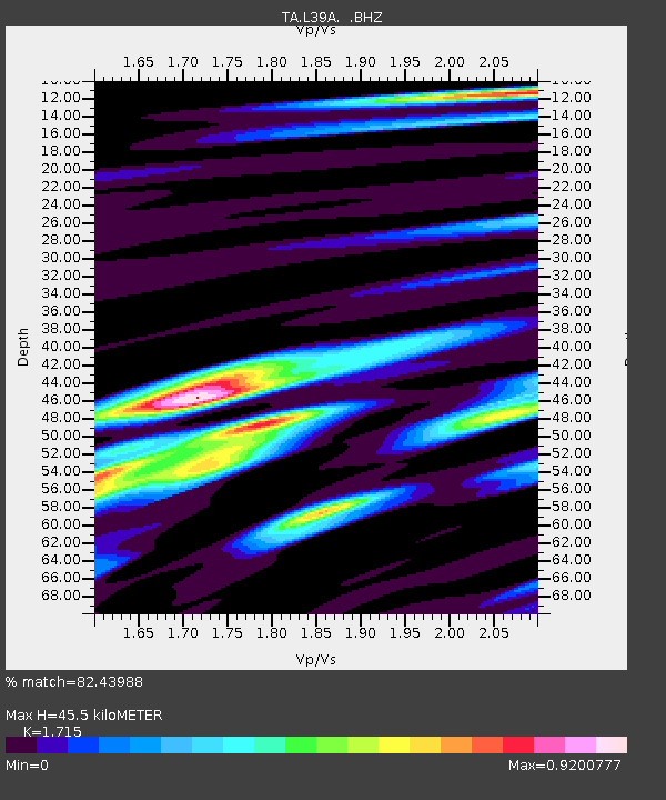
| Estimated Moho Depth: |
45.5 km |
| Estimated Crust Vp/Vs: |
1.72 |
| Assumed Crust Vp: |
6.53 km/s |
| Estimated Crust Vs: |
3.808 km/s |
| Estimated Crust Poisson's Ratio: |
0.24 |
|
| Radial Match: |
82.43988 % |
| Radial Bump: |
400 |
| Transverse Match: |
42.796 % |
| Transverse Bump: |
400 |
| SOD ConfigId: |
512894 |
| Insert Time: |
2013-09-14 13:48:48.004 +0000 |
| GWidth: |
2.5 |
| Max Bumps: |
400 |
| Tol: |
0.001 |
|
Signal To Noise
| Channel | StoN | STA | LTA |
| TA:L39A: :BHZ:20130521T05:53:41.674988Z | 2.7800012 | 4.5578892E-7 | 1.6395278E-7 |
| TA:L39A: :BHN:20130521T05:53:41.674988Z | 1.7123021 | 2.7809568E-7 | 1.624104E-7 |
| TA:L39A: :BHE:20130521T05:53:41.674988Z | 0.87269723 | 2.0579238E-7 | 2.3581188E-7 |
| Arrivals |
| Ps | 5.2 SECOND |
| PpPs | 18 SECOND |
| PsPs/PpSs | 23 SECOND |


