You are here: Home > Network List > TA - USArray Transportable Network (new EarthScope stations) Stations List
> Station O47A Sheridan, IN, USA > Earthquake Result Viewer
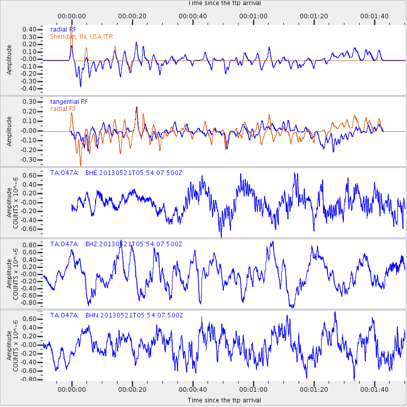
O47A Sheridan, IN, USA - Earthquake Result Viewer
*The percent match for this event was below the threshold and hence no stack was calculated.
| Earthquake location: |
Off East Coast Of Kamchatka |
| Earthquake latitude/longitude: |
52.3/160.1 |
| Earthquake time(UTC): |
2013/05/21 (141) 05:43:21 GMT |
| Earthquake Depth: |
30 km |
| Earthquake Magnitude: |
6.1 MW, 5.8 MB, 6.1 MS, 6.1 MW |
| Earthquake Catalog/Contributor: |
NEIC PDE/NEIC PDE-W |
|
| Network: |
TA USArray Transportable Network (new EarthScope stations) |
| Station: |
O47A Sheridan, IN, USA |
| Lat/Lon: |
40.24 N/86.17 W |
| Elevation: |
278 m |
|
| Distance: |
71.4 deg |
| Az: |
47.654 deg |
| Baz: |
323.619 deg |
| Ray Param: |
$rayparam |
*The percent match for this event was below the threshold and hence was not used in the summary stack. |
|
| Radial Match: |
71.97016 % |
| Radial Bump: |
400 |
| Transverse Match: |
45.953968 % |
| Transverse Bump: |
400 |
| SOD ConfigId: |
512894 |
| Insert Time: |
2013-09-14 13:50:46.264 +0000 |
| GWidth: |
2.5 |
| Max Bumps: |
400 |
| Tol: |
0.001 |
|
Signal To Noise
| Channel | StoN | STA | LTA |
| TA:O47A: :BHZ:20130521T05:54:07.500Z | 2.1611156 | 4.1950133E-7 | 1.9411331E-7 |
| TA:O47A: :BHN:20130521T05:54:07.500Z | 1.1422307 | 2.385817E-7 | 2.0887347E-7 |
| TA:O47A: :BHE:20130521T05:54:07.500Z | 2.4210916 | 3.2354308E-7 | 1.3363521E-7 |
| Arrivals |
| Ps | |
| PpPs | |
| PsPs/PpSs | |


