You are here: Home > Network List > TA - USArray Transportable Network (new EarthScope stations) Stations List
> Station S45A Carrier Mills, IL, USA > Earthquake Result Viewer
S45A Carrier Mills, IL, USA - Earthquake Result Viewer
| Earthquake location: |
Off East Coast Of Kamchatka |
| Earthquake latitude/longitude: |
52.3/160.1 |
| Earthquake time(UTC): |
2013/05/21 (141) 05:43:21 GMT |
| Earthquake Depth: |
30 km |
| Earthquake Magnitude: |
6.1 MW, 5.8 MB, 6.1 MS, 6.1 MW |
| Earthquake Catalog/Contributor: |
NEIC PDE/NEIC PDE-W |
|
| Network: |
TA USArray Transportable Network (new EarthScope stations) |
| Station: |
S45A Carrier Mills, IL, USA |
| Lat/Lon: |
37.68 N/88.58 W |
| Elevation: |
122 m |
|
| Distance: |
72.4 deg |
| Az: |
50.842 deg |
| Baz: |
323.102 deg |
| Ray Param: |
0.053659793 |
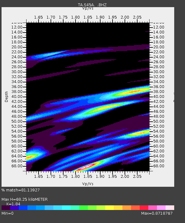
| Estimated Moho Depth: |
68.25 km |
| Estimated Crust Vp/Vs: |
1.84 |
| Assumed Crust Vp: |
6.444 km/s |
| Estimated Crust Vs: |
3.502 km/s |
| Estimated Crust Poisson's Ratio: |
0.29 |
|
| Radial Match: |
81.13927 % |
| Radial Bump: |
400 |
| Transverse Match: |
58.04842 % |
| Transverse Bump: |
400 |
| SOD ConfigId: |
512894 |
| Insert Time: |
2013-09-14 13:52:53.663 +0000 |
| GWidth: |
2.5 |
| Max Bumps: |
400 |
| Tol: |
0.001 |
|

Signal To Noise
| Channel | StoN | STA | LTA |
| TA:S45A: :BHZ:20130521T05:54:13.049988Z | 2.8323843 | 4.7606858E-7 | 1.680805E-7 |
| TA:S45A: :BHN:20130521T05:54:13.049988Z | 1.6388906 | 2.5567687E-7 | 1.5600607E-7 |
| TA:S45A: :BHE:20130521T05:54:13.049988Z | 0.6757217 | 1.35703E-7 | 2.0082676E-7 |
| Arrivals |
| Ps | 9.2 SECOND |
| PpPs | 29 SECOND |
| PsPs/PpSs | 38 SECOND |


