You are here: Home > Network List > TA - USArray Transportable Network (new EarthScope stations) Stations List
> Station T47A Sharon Grove, KY, USA > Earthquake Result Viewer
T47A Sharon Grove, KY, USA - Earthquake Result Viewer
| Earthquake location: |
Off East Coast Of Kamchatka |
| Earthquake latitude/longitude: |
52.3/160.1 |
| Earthquake time(UTC): |
2013/05/21 (141) 05:43:21 GMT |
| Earthquake Depth: |
30 km |
| Earthquake Magnitude: |
6.1 MW, 5.8 MB, 6.1 MS, 6.1 MW |
| Earthquake Catalog/Contributor: |
NEIC PDE/NEIC PDE-W |
|
| Network: |
TA USArray Transportable Network (new EarthScope stations) |
| Station: |
T47A Sharon Grove, KY, USA |
| Lat/Lon: |
36.99 N/87.11 W |
| Elevation: |
217 m |
|
| Distance: |
73.6 deg |
| Az: |
50.282 deg |
| Baz: |
323.829 deg |
| Ray Param: |
0.05283633 |
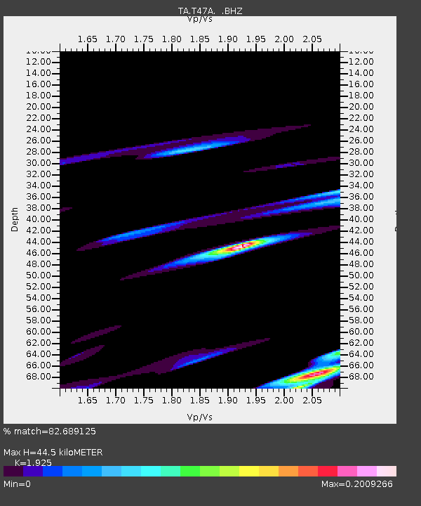
| Estimated Moho Depth: |
44.5 km |
| Estimated Crust Vp/Vs: |
1.92 |
| Assumed Crust Vp: |
6.444 km/s |
| Estimated Crust Vs: |
3.347 km/s |
| Estimated Crust Poisson's Ratio: |
0.32 |
|
| Radial Match: |
82.689125 % |
| Radial Bump: |
400 |
| Transverse Match: |
75.77211 % |
| Transverse Bump: |
397 |
| SOD ConfigId: |
512894 |
| Insert Time: |
2013-09-14 13:53:30.254 +0000 |
| GWidth: |
2.5 |
| Max Bumps: |
400 |
| Tol: |
0.001 |
|

Signal To Noise
| Channel | StoN | STA | LTA |
| TA:T47A: :BHZ:20130521T05:54:20.450012Z | 3.661205 | 6.7870974E-7 | 1.8537878E-7 |
| TA:T47A: :BHN:20130521T05:54:20.450012Z | 2.6224704 | 3.1935684E-7 | 1.217771E-7 |
| TA:T47A: :BHE:20130521T05:54:20.450012Z | 1.7826879 | 3.2094945E-7 | 1.8003682E-7 |
| Arrivals |
| Ps | 6.6 SECOND |
| PpPs | 20 SECOND |
| PsPs/PpSs | 26 SECOND |


