You are here: Home > Network List > PS - Pacific21 Stations List
> Station TSK Tsukuba, Japan > Earthquake Result Viewer
TSK Tsukuba, Japan - Earthquake Result Viewer
| Earthquake location: |
Banda Sea |
| Earthquake latitude/longitude: |
-7.0/128.9 |
| Earthquake time(UTC): |
2000/07/15 (197) 07:13:44 GMT |
| Earthquake Depth: |
218 km |
| Earthquake Magnitude: |
5.6 MB, 5.9 MW, 5.9 MW |
| Earthquake Catalog/Contributor: |
WHDF/NEIC |
|
| Network: |
PS Pacific21 |
| Station: |
TSK Tsukuba, Japan |
| Lat/Lon: |
36.21 N/140.11 E |
| Elevation: |
350 m |
|
| Distance: |
44.3 deg |
| Az: |
12.98 deg |
| Baz: |
196.002 deg |
| Ray Param: |
0.07116409 |
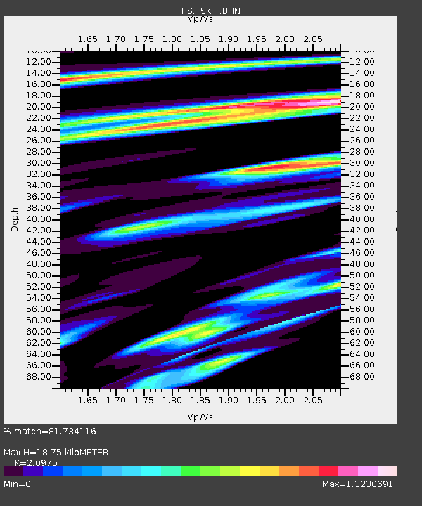
| Estimated Moho Depth: |
18.75 km |
| Estimated Crust Vp/Vs: |
2.10 |
| Assumed Crust Vp: |
6.24 km/s |
| Estimated Crust Vs: |
2.975 km/s |
| Estimated Crust Poisson's Ratio: |
0.35 |
|
| Radial Match: |
81.734116 % |
| Radial Bump: |
400 |
| Transverse Match: |
69.12436 % |
| Transverse Bump: |
372 |
| SOD ConfigId: |
3753 |
| Insert Time: |
2010-02-27 03:47:06.886 +0000 |
| GWidth: |
2.5 |
| Max Bumps: |
400 |
| Tol: |
0.001 |
|

Signal To Noise
| Channel | StoN | STA | LTA |
| PS:TSK: :BHN:20000715T07:21:02.004005Z | 5.582084 | 7.1507804E-7 | 1.2810234E-7 |
| PS:TSK: :BHE:20000715T07:21:02.004005Z | 3.43383 | 4.8347596E-7 | 1.4079787E-7 |
| PS:TSK: :BHZ:20000715T07:21:02.004005Z | 10.426733 | 1.5250189E-6 | 1.4626048E-7 |
| Arrivals |
| Ps | 3.5 SECOND |
| PpPs | 8.9 SECOND |
| PsPs/PpSs | 12 SECOND |


