You are here: Home > Network List > TA - USArray Transportable Network (new EarthScope stations) Stations List
> Station R11A Troy Canyon, Currant, NV, USA > Earthquake Result Viewer
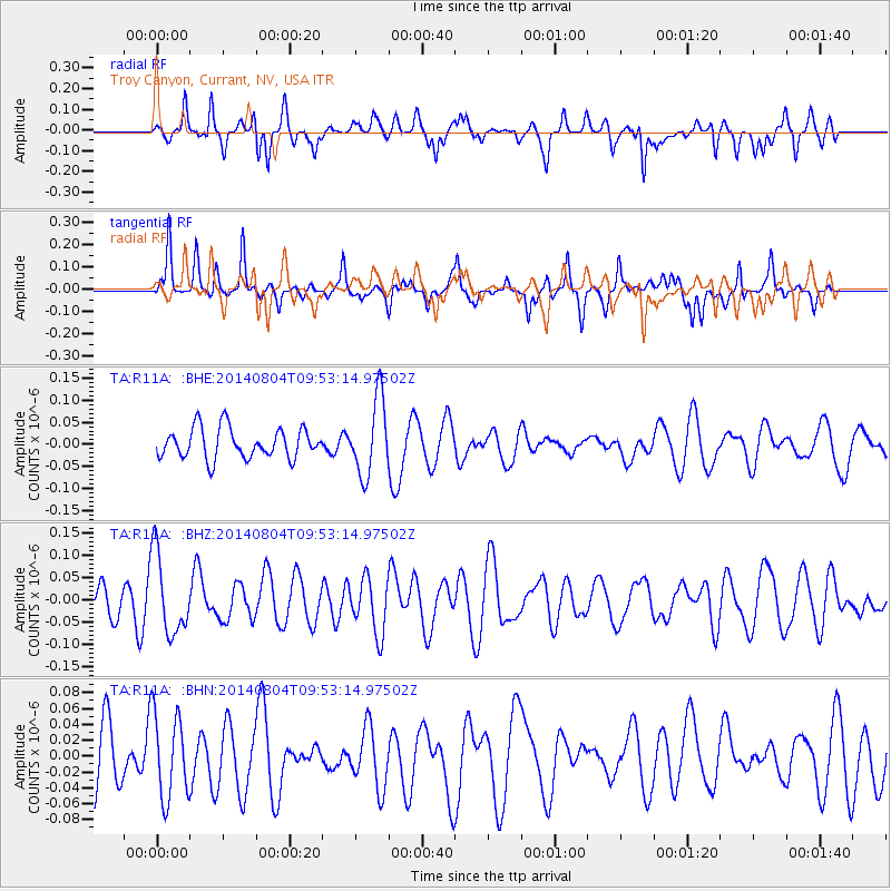
R11A Troy Canyon, Currant, NV, USA - Earthquake Result Viewer
*The percent match for this event was below the threshold and hence no stack was calculated.
| Earthquake location: |
E. Caroline Islands, Micronesia |
| Earthquake latitude/longitude: |
0.8/146.2 |
| Earthquake time(UTC): |
2014/08/04 (216) 09:40:19 GMT |
| Earthquake Depth: |
10 km |
| Earthquake Magnitude: |
5.1 MW, 5.2 mb |
| Earthquake Catalog/Contributor: |
ISC/ISC |
|
| Network: |
TA USArray Transportable Network (new EarthScope stations) |
| Station: |
R11A Troy Canyon, Currant, NV, USA |
| Lat/Lon: |
38.35 N/115.59 W |
| Elevation: |
1756 m |
|
| Distance: |
95.9 deg |
| Az: |
51.484 deg |
| Baz: |
275.717 deg |
| Ray Param: |
$rayparam |
*The percent match for this event was below the threshold and hence was not used in the summary stack. |
|
| Radial Match: |
50.77402 % |
| Radial Bump: |
371 |
| Transverse Match: |
68.50277 % |
| Transverse Bump: |
276 |
| SOD ConfigId: |
3390531 |
| Insert Time: |
2019-04-13 05:21:59.855 +0000 |
| GWidth: |
2.5 |
| Max Bumps: |
400 |
| Tol: |
0.001 |
|
Signal To Noise
| Channel | StoN | STA | LTA |
| TA:R11A: :BHZ:20140804T09:53:14.97502Z | 1.7427592 | 9.013091E-8 | 5.171736E-8 |
| TA:R11A: :BHN:20140804T09:53:14.97502Z | 1.7418407 | 5.3629577E-8 | 3.0789025E-8 |
| TA:R11A: :BHE:20140804T09:53:14.97502Z | 2.530296 | 8.616825E-8 | 3.405461E-8 |
| Arrivals |
| Ps | |
| PpPs | |
| PsPs/PpSs | |


