You are here: Home > Network List > PS - Pacific21 Stations List
> Station TSK Tsukuba, Japan > Earthquake Result Viewer
TSK Tsukuba, Japan - Earthquake Result Viewer
| Earthquake location: |
Mindanao, Philippines |
| Earthquake latitude/longitude: |
6.9/126.8 |
| Earthquake time(UTC): |
2000/10/05 (279) 20:06:14 GMT |
| Earthquake Depth: |
87 km |
| Earthquake Magnitude: |
5.4 MB, 5.5 MS, 6.0 MW, 5.9 MW |
| Earthquake Catalog/Contributor: |
WHDF/NEIC |
|
| Network: |
PS Pacific21 |
| Station: |
TSK Tsukuba, Japan |
| Lat/Lon: |
36.21 N/140.11 E |
| Elevation: |
350 m |
|
| Distance: |
31.7 deg |
| Az: |
20.746 deg |
| Baz: |
205.779 deg |
| Ray Param: |
0.07876374 |
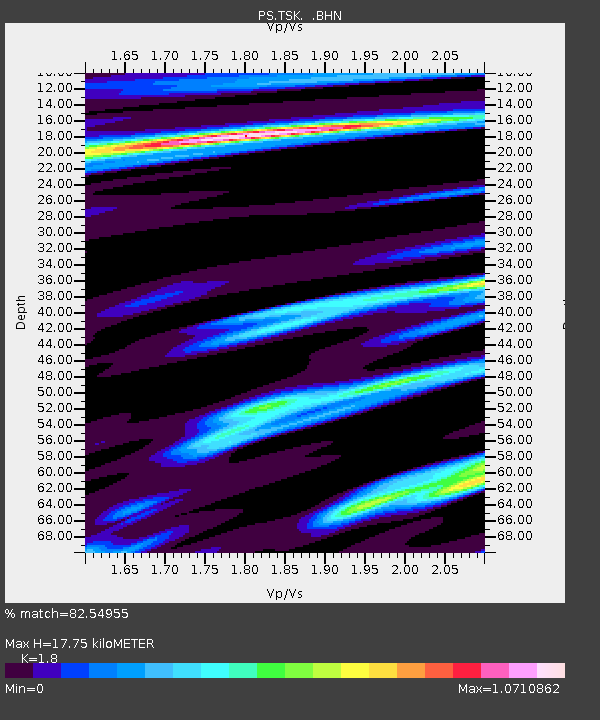
| Estimated Moho Depth: |
17.75 km |
| Estimated Crust Vp/Vs: |
1.80 |
| Assumed Crust Vp: |
6.24 km/s |
| Estimated Crust Vs: |
3.467 km/s |
| Estimated Crust Poisson's Ratio: |
0.28 |
|
| Radial Match: |
82.54955 % |
| Radial Bump: |
270 |
| Transverse Match: |
61.305344 % |
| Transverse Bump: |
400 |
| SOD ConfigId: |
3744 |
| Insert Time: |
2010-02-27 03:47:11.291 +0000 |
| GWidth: |
2.5 |
| Max Bumps: |
400 |
| Tol: |
0.001 |
|

Signal To Noise
| Channel | StoN | STA | LTA |
| PS:TSK: :BHN:20001005T20:11:58.750011Z | 0.99775124 | 2.0788698E-7 | 2.0835553E-7 |
| PS:TSK: :BHE:20001005T20:11:58.750011Z | 1.6721027 | 2.5377037E-7 | 1.5176721E-7 |
| PS:TSK: :BHZ:20001005T20:11:58.750011Z | 1.2969825 | 3.1974125E-7 | 2.4652704E-7 |
| Arrivals |
| Ps | 2.4 SECOND |
| PpPs | 7.4 SECOND |
| PsPs/PpSs | 9.9 SECOND |


