You are here: Home > Network List > US - United States National Seismic Network Stations List
> Station MSO Missoula, Montana, USA > Earthquake Result Viewer
MSO Missoula, Montana, USA - Earthquake Result Viewer
*The percent match for this event was below the threshold and hence no stack was calculated.
| Earthquake location: |
Off East Coast Of Kamchatka |
| Earthquake latitude/longitude: |
52.3/160.1 |
| Earthquake time(UTC): |
2013/05/21 (141) 05:43:21 GMT |
| Earthquake Depth: |
30 km |
| Earthquake Magnitude: |
6.1 MW, 5.8 MB, 6.1 MS, 6.1 MW |
| Earthquake Catalog/Contributor: |
NEIC PDE/NEIC PDE-W |
|
| Network: |
US United States National Seismic Network |
| Station: |
MSO Missoula, Montana, USA |
| Lat/Lon: |
46.83 N/113.94 W |
| Elevation: |
1264 m |
|
| Distance: |
52.9 deg |
| Az: |
59.173 deg |
| Baz: |
309.794 deg |
| Ray Param: |
$rayparam |
*The percent match for this event was below the threshold and hence was not used in the summary stack. |
|
| Radial Match: |
74.59365 % |
| Radial Bump: |
400 |
| Transverse Match: |
60.926384 % |
| Transverse Bump: |
400 |
| SOD ConfigId: |
512894 |
| Insert Time: |
2013-09-14 13:57:59.962 +0000 |
| GWidth: |
2.5 |
| Max Bumps: |
400 |
| Tol: |
0.001 |
|
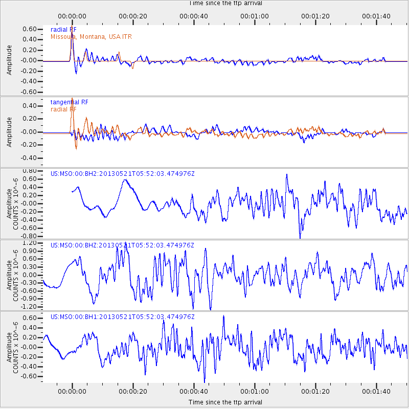
Signal To Noise
| Channel | StoN | STA | LTA |
| US:MSO:00:BHZ:20130521T05:52:03.474976Z | 1.6483415 | 4.6361302E-7 | 2.812603E-7 |
| US:MSO:00:BH1:20130521T05:52:03.474976Z | 0.79284513 | 1.1878507E-7 | 1.4982128E-7 |
| US:MSO:00:BH2:20130521T05:52:03.474976Z | 0.44230726 | 1.1377778E-7 | 2.5723696E-7 |
| Arrivals |
| Ps | |
| PpPs | |
| PsPs/PpSs | |


