You are here: Home > Network List > US - United States National Seismic Network Stations List
> Station MSO Missoula, Montana, USA > Earthquake Result Viewer
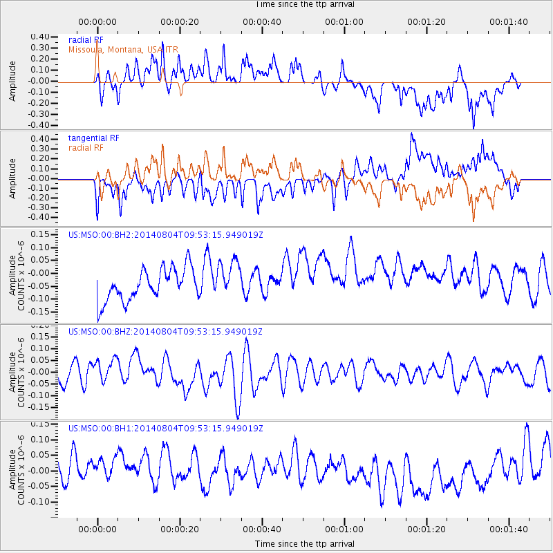
MSO Missoula, Montana, USA - Earthquake Result Viewer
*The percent match for this event was below the threshold and hence no stack was calculated.
| Earthquake location: |
E. Caroline Islands, Micronesia |
| Earthquake latitude/longitude: |
0.8/146.2 |
| Earthquake time(UTC): |
2014/08/04 (216) 09:40:19 GMT |
| Earthquake Depth: |
10 km |
| Earthquake Magnitude: |
5.1 MW, 5.2 mb |
| Earthquake Catalog/Contributor: |
ISC/ISC |
|
| Network: |
US United States National Seismic Network |
| Station: |
MSO Missoula, Montana, USA |
| Lat/Lon: |
46.83 N/113.94 W |
| Elevation: |
1264 m |
|
| Distance: |
96.1 deg |
| Az: |
42.878 deg |
| Baz: |
277.734 deg |
| Ray Param: |
$rayparam |
*The percent match for this event was below the threshold and hence was not used in the summary stack. |
|
| Radial Match: |
54.55734 % |
| Radial Bump: |
400 |
| Transverse Match: |
54.368565 % |
| Transverse Bump: |
400 |
| SOD ConfigId: |
3390531 |
| Insert Time: |
2019-04-13 05:22:23.753 +0000 |
| GWidth: |
2.5 |
| Max Bumps: |
400 |
| Tol: |
0.001 |
|
Signal To Noise
| Channel | StoN | STA | LTA |
| US:MSO:00:BHZ:20140804T09:53:15.949019Z | 0.97217286 | 5.0461377E-8 | 5.1905765E-8 |
| US:MSO:00:BH1:20140804T09:53:15.949019Z | 1.1731262 | 8.0692416E-8 | 6.878409E-8 |
| US:MSO:00:BH2:20140804T09:53:15.949019Z | 1.216801 | 7.468537E-8 | 6.137846E-8 |
| Arrivals |
| Ps | |
| PpPs | |
| PsPs/PpSs | |


