You are here: Home > Network List > PS - Pacific21 Stations List
> Station TSK Tsukuba, Japan > Earthquake Result Viewer
TSK Tsukuba, Japan - Earthquake Result Viewer
| Earthquake location: |
Myanmar |
| Earthquake latitude/longitude: |
26.9/97.2 |
| Earthquake time(UTC): |
2000/06/07 (159) 21:46:55 GMT |
| Earthquake Depth: |
33 km |
| Earthquake Magnitude: |
6.3 MB, 6.5 MS, 6.4 MW, 6.4 MW |
| Earthquake Catalog/Contributor: |
WHDF/NEIC |
|
| Network: |
PS Pacific21 |
| Station: |
TSK Tsukuba, Japan |
| Lat/Lon: |
36.21 N/140.11 E |
| Elevation: |
350 m |
|
| Distance: |
37.5 deg |
| Az: |
64.782 deg |
| Baz: |
267.955 deg |
| Ray Param: |
0.07606363 |
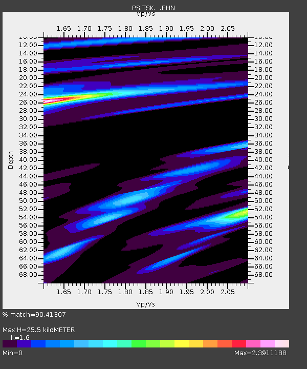
| Estimated Moho Depth: |
25.5 km |
| Estimated Crust Vp/Vs: |
1.60 |
| Assumed Crust Vp: |
6.24 km/s |
| Estimated Crust Vs: |
3.9 km/s |
| Estimated Crust Poisson's Ratio: |
0.18 |
|
| Radial Match: |
90.41307 % |
| Radial Bump: |
347 |
| Transverse Match: |
82.426506 % |
| Transverse Bump: |
335 |
| SOD ConfigId: |
3744 |
| Insert Time: |
2010-02-27 03:47:19.676 +0000 |
| GWidth: |
2.5 |
| Max Bumps: |
400 |
| Tol: |
0.001 |
|

Signal To Noise
| Channel | StoN | STA | LTA |
| PS:TSK: :BHN:20000607T21:53:35.798987Z | 4.937888 | 9.260381E-7 | 1.8753728E-7 |
| PS:TSK: :BHE:20000607T21:53:35.798987Z | 20.868353 | 4.077085E-6 | 1.953717E-7 |
| PS:TSK: :BHZ:20000607T21:53:35.798987Z | 39.89681 | 6.7058295E-6 | 1.6807934E-7 |
| Arrivals |
| Ps | 2.6 SECOND |
| PpPs | 9.8 SECOND |
| PsPs/PpSs | 12 SECOND |


