You are here: Home > Network List > CN - Canadian National Seismograph Network Stations List
> Station INK INUVIK, NT > Earthquake Result Viewer
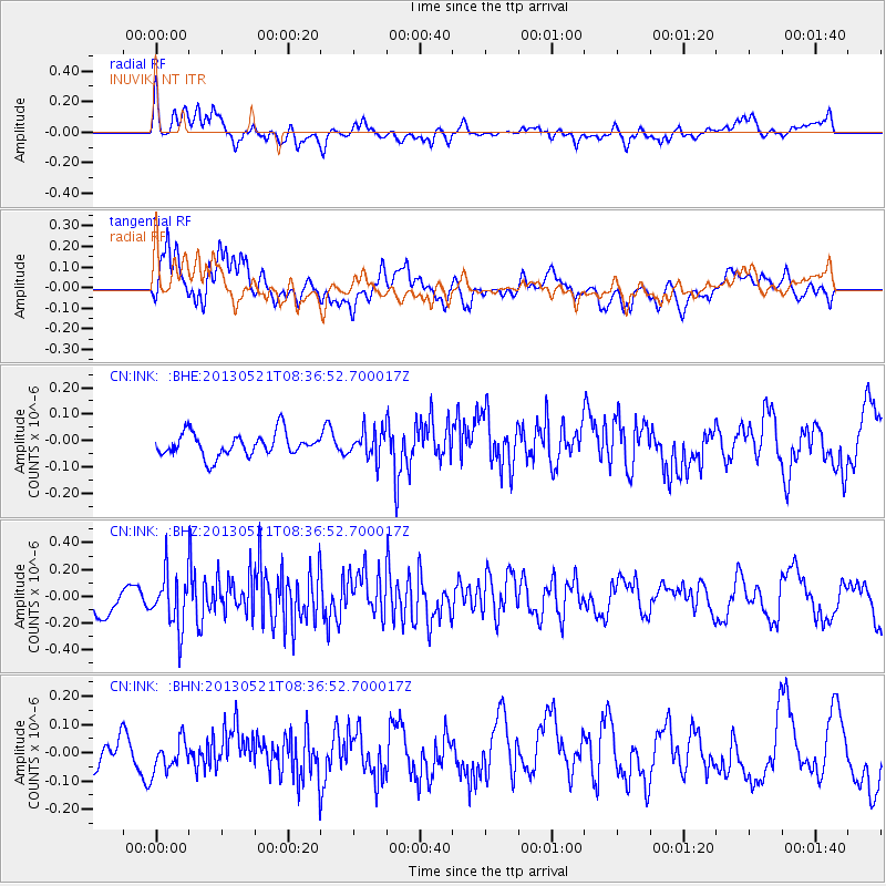
INK INUVIK, NT - Earthquake Result Viewer
*The percent match for this event was below the threshold and hence no stack was calculated.
| Earthquake location: |
Southwestern Ryukyu Isl., Japan |
| Earthquake latitude/longitude: |
23.4/123.7 |
| Earthquake time(UTC): |
2013/05/21 (141) 08:25:53 GMT |
| Earthquake Depth: |
10 km |
| Earthquake Magnitude: |
5.6 MB |
| Earthquake Catalog/Contributor: |
NEIC PDE/NEIC PDE-W |
|
| Network: |
CN Canadian National Seismograph Network |
| Station: |
INK INUVIK, NT |
| Lat/Lon: |
68.31 N/133.53 W |
| Elevation: |
44 m |
|
| Distance: |
73.1 deg |
| Az: |
22.267 deg |
| Baz: |
290.531 deg |
| Ray Param: |
$rayparam |
*The percent match for this event was below the threshold and hence was not used in the summary stack. |
|
| Radial Match: |
63.434956 % |
| Radial Bump: |
400 |
| Transverse Match: |
74.84354 % |
| Transverse Bump: |
400 |
| SOD ConfigId: |
512894 |
| Insert Time: |
2013-09-14 14:07:23.927 +0000 |
| GWidth: |
2.5 |
| Max Bumps: |
400 |
| Tol: |
0.001 |
|
Signal To Noise
| Channel | StoN | STA | LTA |
| CN:INK: :BHZ:20130521T08:36:52.700017Z | 2.1005528 | 2.0239501E-7 | 9.635321E-8 |
| CN:INK: :BHN:20130521T08:36:52.700017Z | 1.0423093 | 5.8777882E-8 | 5.639198E-8 |
| CN:INK: :BHE:20130521T08:36:52.700017Z | 1.2086532 | 5.2879514E-8 | 4.3750774E-8 |
| Arrivals |
| Ps | |
| PpPs | |
| PsPs/PpSs | |


