You are here: Home > Network List > PS - Pacific21 Stations List
> Station TSK Tsukuba, Japan > Earthquake Result Viewer
TSK Tsukuba, Japan - Earthquake Result Viewer
| Earthquake location: |
Santa Cruz Islands |
| Earthquake latitude/longitude: |
-12.4/166.5 |
| Earthquake time(UTC): |
2000/07/16 (198) 17:25:23 GMT |
| Earthquake Depth: |
33 km |
| Earthquake Magnitude: |
5.3 MB, 5.8 MS, 6.1 MW, 6.1 MW |
| Earthquake Catalog/Contributor: |
WHDF/NEIC |
|
| Network: |
PS Pacific21 |
| Station: |
TSK Tsukuba, Japan |
| Lat/Lon: |
36.21 N/140.11 E |
| Elevation: |
350 m |
|
| Distance: |
54.4 deg |
| Az: |
333.752 deg |
| Baz: |
147.707 deg |
| Ray Param: |
0.06541604 |
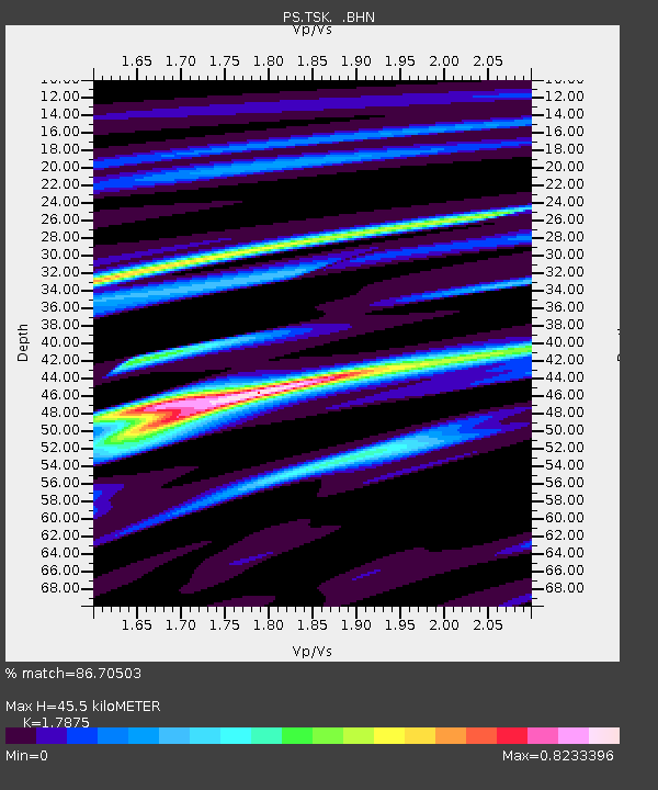
| Estimated Moho Depth: |
45.5 km |
| Estimated Crust Vp/Vs: |
1.79 |
| Assumed Crust Vp: |
6.24 km/s |
| Estimated Crust Vs: |
3.491 km/s |
| Estimated Crust Poisson's Ratio: |
0.27 |
|
| Radial Match: |
86.70503 % |
| Radial Bump: |
400 |
| Transverse Match: |
75.55192 % |
| Transverse Bump: |
400 |
| SOD ConfigId: |
3744 |
| Insert Time: |
2010-02-27 03:47:29.002 +0000 |
| GWidth: |
2.5 |
| Max Bumps: |
400 |
| Tol: |
0.001 |
|

Signal To Noise
| Channel | StoN | STA | LTA |
| PS:TSK: :BHN:20000716T17:34:16.155022Z | 3.8920503 | 3.4636932E-7 | 8.899405E-8 |
| PS:TSK: :BHE:20000716T17:34:16.155022Z | 1.3316042 | 1.072444E-7 | 8.0537745E-8 |
| PS:TSK: :BHZ:20000716T17:34:16.155022Z | 7.189503 | 7.773469E-7 | 1.0812248E-7 |
| Arrivals |
| Ps | 6.0 SECOND |
| PpPs | 19 SECOND |
| PsPs/PpSs | 25 SECOND |


