You are here: Home > Network List > IU - Global Seismograph Network (GSN - IRIS/USGS) Stations List
> Station MAKZ Makanchi, Kazakhstan > Earthquake Result Viewer
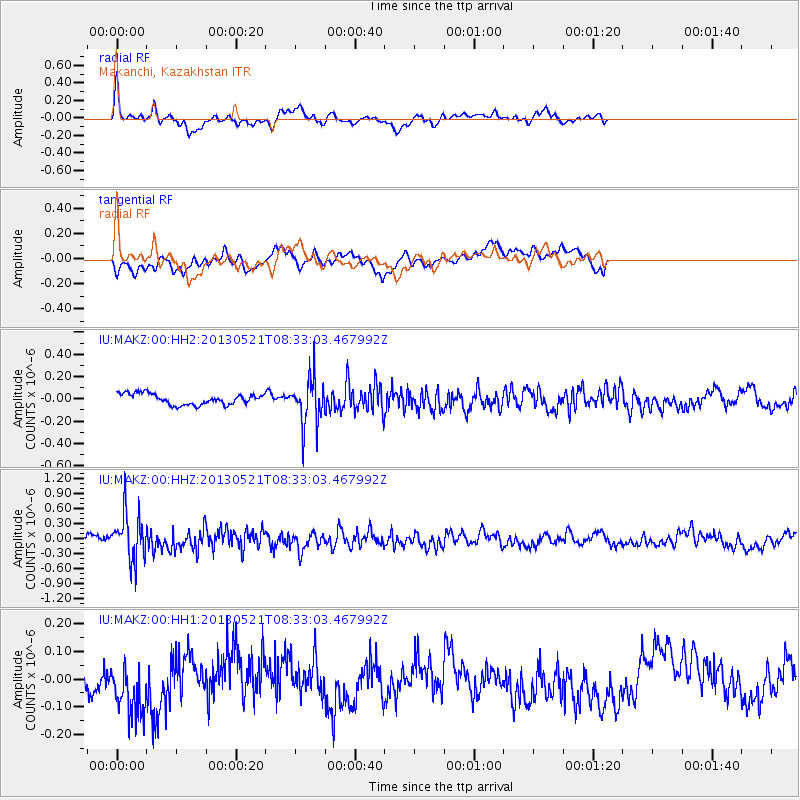
MAKZ Makanchi, Kazakhstan - Earthquake Result Viewer
*The percent match for this event was below the threshold and hence no stack was calculated.
| Earthquake location: |
Southwestern Ryukyu Isl., Japan |
| Earthquake latitude/longitude: |
23.4/123.7 |
| Earthquake time(UTC): |
2013/05/21 (141) 08:25:53 GMT |
| Earthquake Depth: |
10 km |
| Earthquake Magnitude: |
5.6 MB |
| Earthquake Catalog/Contributor: |
NEIC PDE/NEIC PDE-W |
|
| Network: |
IU Global Seismograph Network (GSN - IRIS/USGS) |
| Station: |
MAKZ Makanchi, Kazakhstan |
| Lat/Lon: |
46.81 N/81.98 E |
| Elevation: |
600 m |
|
| Distance: |
40.7 deg |
| Az: |
315.523 deg |
| Baz: |
110.411 deg |
| Ray Param: |
$rayparam |
*The percent match for this event was below the threshold and hence was not used in the summary stack. |
|
| Radial Match: |
73.03121 % |
| Radial Bump: |
400 |
| Transverse Match: |
58.988403 % |
| Transverse Bump: |
400 |
| SOD ConfigId: |
512894 |
| Insert Time: |
2013-09-14 14:11:49.644 +0000 |
| GWidth: |
2.5 |
| Max Bumps: |
400 |
| Tol: |
0.001 |
|
Signal To Noise
| Channel | StoN | STA | LTA |
| IU:MAKZ:00:HHZ:20130521T08:33:03.467992Z | 6.7690253 | 4.6490828E-7 | 6.8681715E-8 |
| IU:MAKZ:00:HH1:20130521T08:33:03.467992Z | 1.5230724 | 1.00007064E-7 | 6.56614E-8 |
| IU:MAKZ:00:HH2:20130521T08:33:03.467992Z | 4.329193 | 2.0853214E-7 | 4.8168825E-8 |
| Arrivals |
| Ps | |
| PpPs | |
| PsPs/PpSs | |


