You are here: Home > Network List > PS - Pacific21 Stations List
> Station TSK Tsukuba, Japan > Earthquake Result Viewer
TSK Tsukuba, Japan - Earthquake Result Viewer

| Earthquake location: |
Western Xizang-India Border Reg. |
| Earthquake latitude/longitude: |
30.5/79.4 |
| Earthquake time(UTC): |
1999/03/28 (087) 19:05:11 GMT |
| Earthquake Depth: |
15 km |
| Earthquake Magnitude: |
6.4 MB, 6.6 MS, 6.6 MW, 6.5 ME |
| Earthquake Catalog/Contributor: |
WHDF/NEIC |
|
| Network: |
PS Pacific21 |
| Station: |
TSK Tsukuba, Japan |
| Lat/Lon: |
36.21 N/140.11 E |
| Elevation: |
350 m |
|
| Distance: |
50.3 deg |
| Az: |
66.431 deg |
| Baz: |
282.016 deg |
| Ray Param: |
0.06813028 |
| Estimated Moho Depth: |
23.5 km |
| Estimated Crust Vp/Vs: |
1.70 |
| Assumed Crust Vp: |
6.24 km/s |
| Estimated Crust Vs: |
3.665 km/s |
| Estimated Crust Poisson's Ratio: |
0.24 |
|
| Radial Match: |
89.23321 % |
| Radial Bump: |
372 |
| Transverse Match: |
82.59209 % |
| Transverse Bump: |
400 |
| SOD ConfigId: |
4480 |
| Insert Time: |
2010-02-27 03:47:44.736 +0000 |
| GWidth: |
2.5 |
| Max Bumps: |
400 |
| Tol: |
0.001 |
|
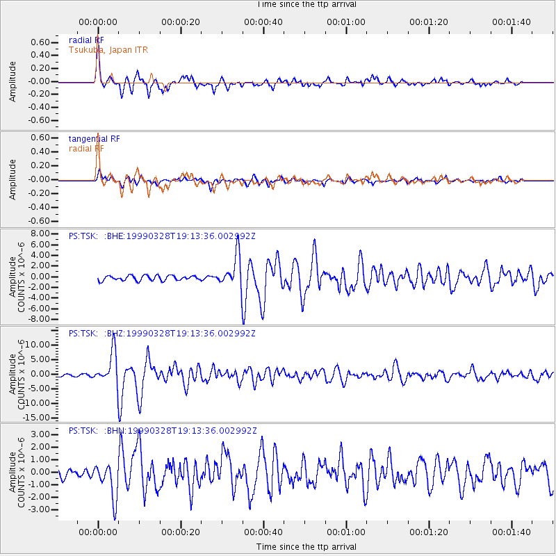
Signal To Noise
| Channel | StoN | STA | LTA |
| PS:TSK: :BHZ:19990328T19:13:36.002992Z | 13.351575 | 5.870168E-6 | 4.3966108E-7 |
| PS:TSK: :BHN:19990328T19:13:36.002992Z | 3.526765 | 1.4580927E-6 | 4.1343628E-7 |
| PS:TSK: :BHE:19990328T19:13:36.002992Z | 6.7724414 | 3.1244267E-6 | 4.6134423E-7 |
| Arrivals |
| Ps | 2.8 SECOND |
| PpPs | 9.6 SECOND |
| PsPs/PpSs | 12 SECOND |


