You are here: Home > Network List > US - United States National Seismic Network Stations List
> Station MSO Missoula, Montana, USA > Earthquake Result Viewer
MSO Missoula, Montana, USA - Earthquake Result Viewer
*The percent match for this event was below the threshold and hence no stack was calculated.
| Earthquake location: |
Southwestern Ryukyu Isl., Japan |
| Earthquake latitude/longitude: |
23.4/123.7 |
| Earthquake time(UTC): |
2013/05/21 (141) 08:25:53 GMT |
| Earthquake Depth: |
10 km |
| Earthquake Magnitude: |
5.6 MB |
| Earthquake Catalog/Contributor: |
NEIC PDE/NEIC PDE-W |
|
| Network: |
US United States National Seismic Network |
| Station: |
MSO Missoula, Montana, USA |
| Lat/Lon: |
46.83 N/113.94 W |
| Elevation: |
1264 m |
|
| Distance: |
92.9 deg |
| Az: |
35.495 deg |
| Baz: |
309.012 deg |
| Ray Param: |
$rayparam |
*The percent match for this event was below the threshold and hence was not used in the summary stack. |
|
| Radial Match: |
54.33334 % |
| Radial Bump: |
400 |
| Transverse Match: |
42.280148 % |
| Transverse Bump: |
400 |
| SOD ConfigId: |
512894 |
| Insert Time: |
2013-09-14 14:17:22.471 +0000 |
| GWidth: |
2.5 |
| Max Bumps: |
400 |
| Tol: |
0.001 |
|
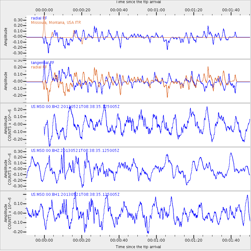
Signal To Noise
| Channel | StoN | STA | LTA |
| US:MSO:00:BHZ:20130521T08:38:35.125005Z | 0.65204906 | 1.1143347E-7 | 1.7089738E-7 |
| US:MSO:00:BH1:20130521T08:38:35.125005Z | 1.1687406 | 8.202152E-8 | 7.017941E-8 |
| US:MSO:00:BH2:20130521T08:38:35.125005Z | 1.1890126 | 1.4251683E-7 | 1.198615E-7 |
| Arrivals |
| Ps | |
| PpPs | |
| PsPs/PpSs | |


