You are here: Home > Network List > CN - Canadian National Seismograph Network Stations List
> Station INK INUVIK, NT > Earthquake Result Viewer
INK INUVIK, NT - Earthquake Result Viewer
*The percent match for this event was below the threshold and hence no stack was calculated.
| Earthquake location: |
Off East Coast Of Kamchatka |
| Earthquake latitude/longitude: |
52.6/160.6 |
| Earthquake time(UTC): |
2013/05/21 (141) 14:51:19 GMT |
| Earthquake Depth: |
37 km |
| Earthquake Magnitude: |
5.6 MW, 5.5 MW |
| Earthquake Catalog/Contributor: |
NEIC PDE/NEIC PDE-W |
|
| Network: |
CN Canadian National Seismograph Network |
| Station: |
INK INUVIK, NT |
| Lat/Lon: |
68.31 N/133.53 W |
| Elevation: |
44 m |
|
| Distance: |
34.1 deg |
| Az: |
37.269 deg |
| Baz: |
276.432 deg |
| Ray Param: |
$rayparam |
*The percent match for this event was below the threshold and hence was not used in the summary stack. |
|
| Radial Match: |
69.045105 % |
| Radial Bump: |
400 |
| Transverse Match: |
66.97747 % |
| Transverse Bump: |
400 |
| SOD ConfigId: |
512894 |
| Insert Time: |
2013-09-14 14:25:57.003 +0000 |
| GWidth: |
2.5 |
| Max Bumps: |
400 |
| Tol: |
0.001 |
|
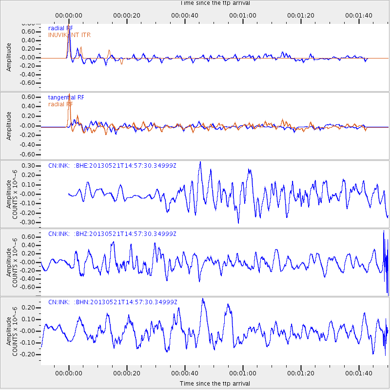
Signal To Noise
| Channel | StoN | STA | LTA |
| CN:INK: :BHZ:20130521T14:57:30.34999Z | 1.674517 | 1.6519552E-7 | 9.8652635E-8 |
| CN:INK: :BHN:20130521T14:57:30.34999Z | 1.0497986 | 7.442882E-8 | 7.089819E-8 |
| CN:INK: :BHE:20130521T14:57:30.34999Z | 1.9522852 | 8.860401E-8 | 4.5384766E-8 |
| Arrivals |
| Ps | |
| PpPs | |
| PsPs/PpSs | |


