You are here: Home > Network List > PS - Pacific21 Stations List
> Station TSK Tsukuba, Japan > Earthquake Result Viewer
TSK Tsukuba, Japan - Earthquake Result Viewer

| Earthquake location: |
Afghanistan-Tajikistan Bord Reg. |
| Earthquake latitude/longitude: |
36.5/71.2 |
| Earthquake time(UTC): |
1995/08/17 (229) 23:14:19 GMT |
| Earthquake Depth: |
239 km |
| Earthquake Magnitude: |
5.7 UNKNOWN, 5.4 MB, 5.6 MW |
| Earthquake Catalog/Contributor: |
WHDF/NEIC |
|
| Network: |
PS Pacific21 |
| Station: |
TSK Tsukuba, Japan |
| Lat/Lon: |
36.21 N/140.11 E |
| Elevation: |
350 m |
|
| Distance: |
54.4 deg |
| Az: |
68.175 deg |
| Baz: |
292.283 deg |
| Ray Param: |
0.064626545 |
| Estimated Moho Depth: |
50.25 km |
| Estimated Crust Vp/Vs: |
1.84 |
| Assumed Crust Vp: |
6.24 km/s |
| Estimated Crust Vs: |
3.387 km/s |
| Estimated Crust Poisson's Ratio: |
0.29 |
|
| Radial Match: |
85.84084 % |
| Radial Bump: |
400 |
| Transverse Match: |
73.31732 % |
| Transverse Bump: |
400 |
| SOD ConfigId: |
4480 |
| Insert Time: |
2010-02-27 03:48:13.284 +0000 |
| GWidth: |
2.5 |
| Max Bumps: |
400 |
| Tol: |
0.001 |
|
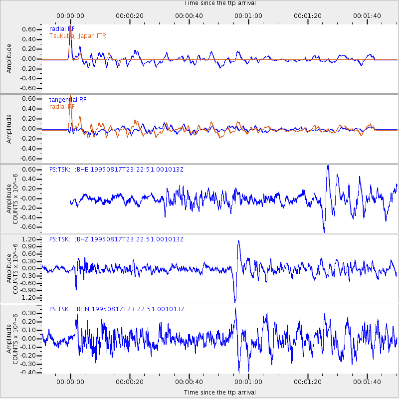
Signal To Noise
| Channel | StoN | STA | LTA |
| PS:TSK: :BHZ:19950817T23:22:51.001013Z | 3.6931973 | 2.5453033E-7 | 6.8918695E-8 |
| PS:TSK: :BHN:19950817T23:22:51.001013Z | 2.2275238 | 1.1043117E-7 | 4.9575753E-8 |
| PS:TSK: :BHE:19950817T23:22:51.001013Z | 1.7694021 | 1.1191515E-7 | 6.325026E-8 |
| Arrivals |
| Ps | 7.1 SECOND |
| PpPs | 22 SECOND |
| PsPs/PpSs | 29 SECOND |


