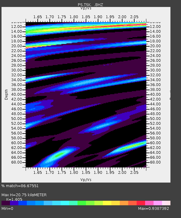
TSK Tsukuba, Japan - Earthquake Result Viewer

Earthquake location: New Britain Region, P.N.G.
Earthquake latitude/longitude: -5.2/152.9
Earthquake time(UTC): 1999/05/17 (137) 10:07:56 GMT
Earthquake Depth: 27 km
Earthquake Magnitude: 5.5 MB, 6.9 MS, 6.7 MW, 6.0 ME
Earthquake Catalog/Contributor: WHDF/NEIC
Network: PS Pacific21
Station: TSK Tsukuba, Japan
Lat/Lon: 36.21 N/140.11 E
Elevation: 350 m
Distance: 42.9 deg
Az: 344.768 deg
Baz: 161.121 deg
Ray Param: 0.072870374
Estimated Moho Depth: 20.75 km
Estimated Crust Vp/Vs: 1.61
Assumed Crust Vp: 6.24 km/s
Estimated Crust Vs: 3.888 km/s
Estimated Crust Poisson's Ratio: 0.18
Radial Match: 86.67551 %
Radial Bump: 400
Transverse Match: 80.92026 %
Transverse Bump: 400
SOD ConfigId: 4480
Insert Time: 2010-02-27 03:48:18.998 +0000
GWidth: 2.5
Max Bumps: 400
Tol: 0.001

Signal To Noise

ChannelStoNSTALTA
PS:TSK: :BHZ:19990517T10:15:21.65401Z16.0840513.2331957E-62.0101875E-7
PS:TSK: :BHN:19990517T10:15:21.65401Z10.5079911.7237868E-61.6404532E-7
PS:TSK: :BHE:19990517T10:15:21.65401Z2.43365724.1748447E-71.7154612E-7
Arrivals
Ps2.2 SECOND
PpPs8.1 SECOND
PsPs/PpSs10 SECOND