You are here: Home > Network List > TA - USArray Transportable Network (new EarthScope stations) Stations List
> Station C40A Isle Royale National Park, MI, USA > Earthquake Result Viewer
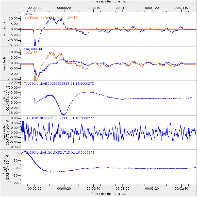
C40A Isle Royale National Park, MI, USA - Earthquake Result Viewer
*The percent match for this event was below the threshold and hence no stack was calculated.
| Earthquake location: |
Off East Coast Of Kamchatka |
| Earthquake latitude/longitude: |
52.6/160.6 |
| Earthquake time(UTC): |
2013/05/21 (141) 14:51:19 GMT |
| Earthquake Depth: |
37 km |
| Earthquake Magnitude: |
5.6 MW, 5.5 MW |
| Earthquake Catalog/Contributor: |
NEIC PDE/NEIC PDE-W |
|
| Network: |
TA USArray Transportable Network (new EarthScope stations) |
| Station: |
C40A Isle Royale National Park, MI, USA |
| Lat/Lon: |
47.92 N/89.15 W |
| Elevation: |
216 m |
|
| Distance: |
63.6 deg |
| Az: |
44.806 deg |
| Baz: |
320.273 deg |
| Ray Param: |
$rayparam |
*The percent match for this event was below the threshold and hence was not used in the summary stack. |
|
| Radial Match: |
74.716805 % |
| Radial Bump: |
400 |
| Transverse Match: |
84.052246 % |
| Transverse Bump: |
358 |
| SOD ConfigId: |
512894 |
| Insert Time: |
2013-09-14 14:43:57.453 +0000 |
| GWidth: |
2.5 |
| Max Bumps: |
400 |
| Tol: |
0.001 |
|
Signal To Noise
| Channel | StoN | STA | LTA |
| TA:C40A: :BHZ:20130521T15:01:16.200027Z | 0.8472912 | 2.8848544E-7 | 3.404797E-7 |
| TA:C40A: :BHN:20130521T15:01:16.200027Z | 0.6029702 | 8.1319795E-6 | 1.3486536E-5 |
| TA:C40A: :BHE:20130521T15:01:16.200027Z | 1.5336897 | 9.773242E-6 | 6.3723724E-6 |
| Arrivals |
| Ps | |
| PpPs | |
| PsPs/PpSs | |


