You are here: Home > Network List > TA - USArray Transportable Network (new EarthScope stations) Stations List
> Station E47A Iron Bridge, ON, CAN > Earthquake Result Viewer
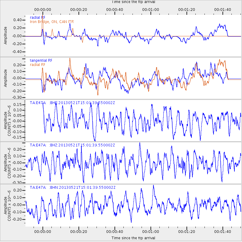
E47A Iron Bridge, ON, CAN - Earthquake Result Viewer
*The percent match for this event was below the threshold and hence no stack was calculated.
| Earthquake location: |
Off East Coast Of Kamchatka |
| Earthquake latitude/longitude: |
52.6/160.6 |
| Earthquake time(UTC): |
2013/05/21 (141) 14:51:19 GMT |
| Earthquake Depth: |
37 km |
| Earthquake Magnitude: |
5.6 MW, 5.5 MW |
| Earthquake Catalog/Contributor: |
NEIC PDE/NEIC PDE-W |
|
| Network: |
TA USArray Transportable Network (new EarthScope stations) |
| Station: |
E47A Iron Bridge, ON, CAN |
| Lat/Lon: |
46.45 N/83.28 W |
| Elevation: |
246 m |
|
| Distance: |
67.2 deg |
| Az: |
42.33 deg |
| Baz: |
323.54 deg |
| Ray Param: |
$rayparam |
*The percent match for this event was below the threshold and hence was not used in the summary stack. |
|
| Radial Match: |
25.012787 % |
| Radial Bump: |
400 |
| Transverse Match: |
25.871468 % |
| Transverse Bump: |
400 |
| SOD ConfigId: |
512894 |
| Insert Time: |
2013-09-14 14:44:30.593 +0000 |
| GWidth: |
2.5 |
| Max Bumps: |
400 |
| Tol: |
0.001 |
|
Signal To Noise
| Channel | StoN | STA | LTA |
| TA:E47A: :BHZ:20130521T15:01:39.550002Z | 0.9685797 | 1.1462684E-7 | 1.18345284E-7 |
| TA:E47A: :BHN:20130521T15:01:39.550002Z | 0.7259434 | 1.8635237E-7 | 2.5670371E-7 |
| TA:E47A: :BHE:20130521T15:01:39.550002Z | 1.4009652 | 9.2789016E-8 | 6.6232204E-8 |
| Arrivals |
| Ps | |
| PpPs | |
| PsPs/PpSs | |


