You are here: Home > Network List > TA - USArray Transportable Network (new EarthScope stations) Stations List
> Station F39A Loretta, WI, USA > Earthquake Result Viewer
F39A Loretta, WI, USA - Earthquake Result Viewer
*The percent match for this event was below the threshold and hence no stack was calculated.
| Earthquake location: |
Off East Coast Of Kamchatka |
| Earthquake latitude/longitude: |
52.6/160.6 |
| Earthquake time(UTC): |
2013/05/21 (141) 14:51:19 GMT |
| Earthquake Depth: |
37 km |
| Earthquake Magnitude: |
5.6 MW, 5.5 MW |
| Earthquake Catalog/Contributor: |
NEIC PDE/NEIC PDE-W |
|
| Network: |
TA USArray Transportable Network (new EarthScope stations) |
| Station: |
F39A Loretta, WI, USA |
| Lat/Lon: |
45.92 N/90.92 W |
| Elevation: |
440 m |
|
| Distance: |
64.4 deg |
| Az: |
47.267 deg |
| Baz: |
320.066 deg |
| Ray Param: |
$rayparam |
*The percent match for this event was below the threshold and hence was not used in the summary stack. |
|
| Radial Match: |
23.328918 % |
| Radial Bump: |
400 |
| Transverse Match: |
60.91387 % |
| Transverse Bump: |
400 |
| SOD ConfigId: |
512894 |
| Insert Time: |
2013-09-14 14:44:51.570 +0000 |
| GWidth: |
2.5 |
| Max Bumps: |
400 |
| Tol: |
0.001 |
|
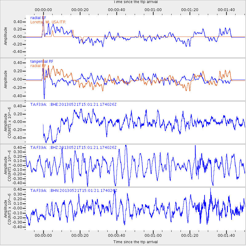
Signal To Noise
| Channel | StoN | STA | LTA |
| TA:F39A: :BHZ:20130521T15:01:21.174026Z | 0.9575487 | 1.3118003E-7 | 1.3699568E-7 |
| TA:F39A: :BHN:20130521T15:01:21.174026Z | 0.7750293 | 2.1453535E-7 | 2.7680935E-7 |
| TA:F39A: :BHE:20130521T15:01:21.174026Z | 0.5360105 | 1.3191891E-7 | 2.4611253E-7 |
| Arrivals |
| Ps | |
| PpPs | |
| PsPs/PpSs | |


