You are here: Home > Network List > TA - USArray Transportable Network (new EarthScope stations) Stations List
> Station K39A Oelwein, IA, USA > Earthquake Result Viewer
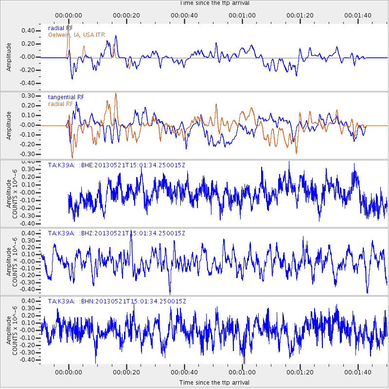
K39A Oelwein, IA, USA - Earthquake Result Viewer
*The percent match for this event was below the threshold and hence no stack was calculated.
| Earthquake location: |
Off East Coast Of Kamchatka |
| Earthquake latitude/longitude: |
52.6/160.6 |
| Earthquake time(UTC): |
2013/05/21 (141) 14:51:19 GMT |
| Earthquake Depth: |
37 km |
| Earthquake Magnitude: |
5.6 MW, 5.5 MW |
| Earthquake Catalog/Contributor: |
NEIC PDE/NEIC PDE-W |
|
| Network: |
TA USArray Transportable Network (new EarthScope stations) |
| Station: |
K39A Oelwein, IA, USA |
| Lat/Lon: |
42.71 N/91.89 W |
| Elevation: |
332 m |
|
| Distance: |
66.4 deg |
| Az: |
50.11 deg |
| Baz: |
320.576 deg |
| Ray Param: |
$rayparam |
*The percent match for this event was below the threshold and hence was not used in the summary stack. |
|
| Radial Match: |
50.64824 % |
| Radial Bump: |
400 |
| Transverse Match: |
36.247604 % |
| Transverse Bump: |
400 |
| SOD ConfigId: |
512894 |
| Insert Time: |
2013-09-14 14:47:05.490 +0000 |
| GWidth: |
2.5 |
| Max Bumps: |
400 |
| Tol: |
0.001 |
|
Signal To Noise
| Channel | StoN | STA | LTA |
| TA:K39A: :BHZ:20130521T15:01:34.250015Z | 1.1860626 | 1.3509865E-7 | 1.13905166E-7 |
| TA:K39A: :BHN:20130521T15:01:34.250015Z | 0.96524656 | 9.972364E-8 | 1.0331417E-7 |
| TA:K39A: :BHE:20130521T15:01:34.250015Z | 1.1914926 | 1.5268024E-7 | 1.2814202E-7 |
| Arrivals |
| Ps | |
| PpPs | |
| PsPs/PpSs | |


