You are here: Home > Network List > TA - USArray Transportable Network (new EarthScope stations) Stations List
> Station K40A Colesburg, IA, USA > Earthquake Result Viewer
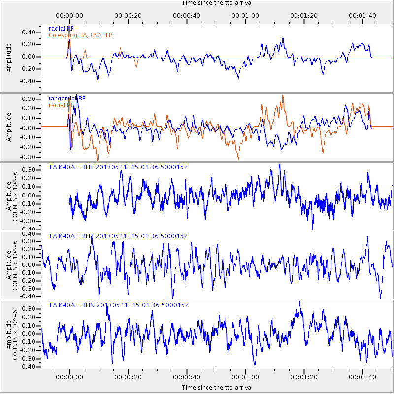
K40A Colesburg, IA, USA - Earthquake Result Viewer
*The percent match for this event was below the threshold and hence no stack was calculated.
| Earthquake location: |
Off East Coast Of Kamchatka |
| Earthquake latitude/longitude: |
52.6/160.6 |
| Earthquake time(UTC): |
2013/05/21 (141) 14:51:19 GMT |
| Earthquake Depth: |
37 km |
| Earthquake Magnitude: |
5.6 MW, 5.5 MW |
| Earthquake Catalog/Contributor: |
NEIC PDE/NEIC PDE-W |
|
| Network: |
TA USArray Transportable Network (new EarthScope stations) |
| Station: |
K40A Colesburg, IA, USA |
| Lat/Lon: |
42.70 N/91.14 W |
| Elevation: |
274 m |
|
| Distance: |
66.8 deg |
| Az: |
49.647 deg |
| Baz: |
320.898 deg |
| Ray Param: |
$rayparam |
*The percent match for this event was below the threshold and hence was not used in the summary stack. |
|
| Radial Match: |
34.254364 % |
| Radial Bump: |
400 |
| Transverse Match: |
42.571728 % |
| Transverse Bump: |
400 |
| SOD ConfigId: |
512894 |
| Insert Time: |
2013-09-14 14:47:08.007 +0000 |
| GWidth: |
2.5 |
| Max Bumps: |
400 |
| Tol: |
0.001 |
|
Signal To Noise
| Channel | StoN | STA | LTA |
| TA:K40A: :BHZ:20130521T15:01:36.500015Z | 0.9816206 | 1.3450682E-7 | 1.3702525E-7 |
| TA:K40A: :BHN:20130521T15:01:36.500015Z | 0.71997494 | 1.2846311E-7 | 1.784272E-7 |
| TA:K40A: :BHE:20130521T15:01:36.500015Z | 0.8003856 | 9.751083E-8 | 1.2182981E-7 |
| Arrivals |
| Ps | |
| PpPs | |
| PsPs/PpSs | |


