You are here: Home > Network List > TA - USArray Transportable Network (new EarthScope stations) Stations List
> Station L40A Anamosa, IA, USA > Earthquake Result Viewer
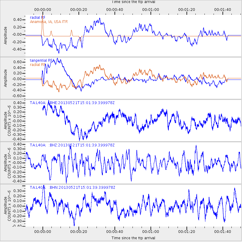
L40A Anamosa, IA, USA - Earthquake Result Viewer
*The percent match for this event was below the threshold and hence no stack was calculated.
| Earthquake location: |
Off East Coast Of Kamchatka |
| Earthquake latitude/longitude: |
52.6/160.6 |
| Earthquake time(UTC): |
2013/05/21 (141) 14:51:19 GMT |
| Earthquake Depth: |
37 km |
| Earthquake Magnitude: |
5.6 MW, 5.5 MW |
| Earthquake Catalog/Contributor: |
NEIC PDE/NEIC PDE-W |
|
| Network: |
TA USArray Transportable Network (new EarthScope stations) |
| Station: |
L40A Anamosa, IA, USA |
| Lat/Lon: |
42.06 N/91.22 W |
| Elevation: |
242 m |
|
| Distance: |
67.2 deg |
| Az: |
50.135 deg |
| Baz: |
321.033 deg |
| Ray Param: |
$rayparam |
*The percent match for this event was below the threshold and hence was not used in the summary stack. |
|
| Radial Match: |
51.453415 % |
| Radial Bump: |
400 |
| Transverse Match: |
67.62372 % |
| Transverse Bump: |
400 |
| SOD ConfigId: |
512894 |
| Insert Time: |
2013-09-14 14:47:46.267 +0000 |
| GWidth: |
2.5 |
| Max Bumps: |
400 |
| Tol: |
0.001 |
|
Signal To Noise
| Channel | StoN | STA | LTA |
| TA:L40A: :BHZ:20130521T15:01:39.399978Z | 1.5756226 | 1.7506379E-7 | 1.1110769E-7 |
| TA:L40A: :BHN:20130521T15:01:39.399978Z | 1.9421268 | 2.9447634E-7 | 1.516257E-7 |
| TA:L40A: :BHE:20130521T15:01:39.399978Z | 0.5223024 | 1.318976E-7 | 2.525311E-7 |
| Arrivals |
| Ps | |
| PpPs | |
| PsPs/PpSs | |


