You are here: Home > Network List > TA - USArray Transportable Network (new EarthScope stations) Stations List
> Station U59A Littleton, NC, USA > Earthquake Result Viewer
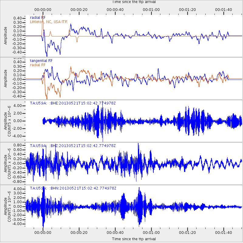
U59A Littleton, NC, USA - Earthquake Result Viewer
*The percent match for this event was below the threshold and hence no stack was calculated.
| Earthquake location: |
Off East Coast Of Kamchatka |
| Earthquake latitude/longitude: |
52.6/160.6 |
| Earthquake time(UTC): |
2013/05/21 (141) 14:51:19 GMT |
| Earthquake Depth: |
37 km |
| Earthquake Magnitude: |
5.6 MW, 5.5 MW |
| Earthquake Catalog/Contributor: |
NEIC PDE/NEIC PDE-W |
|
| Network: |
TA USArray Transportable Network (new EarthScope stations) |
| Station: |
U59A Littleton, NC, USA |
| Lat/Lon: |
36.35 N/77.79 W |
| Elevation: |
99 m |
|
| Distance: |
77.9 deg |
| Az: |
44.703 deg |
| Baz: |
327.885 deg |
| Ray Param: |
$rayparam |
*The percent match for this event was below the threshold and hence was not used in the summary stack. |
|
| Radial Match: |
43.938404 % |
| Radial Bump: |
400 |
| Transverse Match: |
40.329716 % |
| Transverse Bump: |
400 |
| SOD ConfigId: |
512894 |
| Insert Time: |
2013-09-14 14:52:52.367 +0000 |
| GWidth: |
2.5 |
| Max Bumps: |
400 |
| Tol: |
0.001 |
|
Signal To Noise
| Channel | StoN | STA | LTA |
| TA:U59A: :BHZ:20130521T15:02:42.774978Z | 1.6682246 | 2.93461E-7 | 1.7591216E-7 |
| TA:U59A: :BHN:20130521T15:02:42.774978Z | 2.7890017 | 1.8432869E-6 | 6.609128E-7 |
| TA:U59A: :BHE:20130521T15:02:42.774978Z | 2.7922826 | 2.2271122E-6 | 7.9759553E-7 |
| Arrivals |
| Ps | |
| PpPs | |
| PsPs/PpSs | |


