You are here: Home > Network List > TA - USArray Transportable Network (new EarthScope stations) Stations List
> Station W47A Westpoint, TN, USA > Earthquake Result Viewer
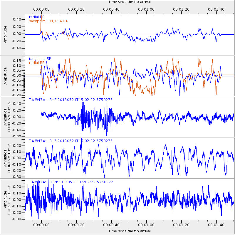
W47A Westpoint, TN, USA - Earthquake Result Viewer
*The percent match for this event was below the threshold and hence no stack was calculated.
| Earthquake location: |
Off East Coast Of Kamchatka |
| Earthquake latitude/longitude: |
52.6/160.6 |
| Earthquake time(UTC): |
2013/05/21 (141) 14:51:19 GMT |
| Earthquake Depth: |
37 km |
| Earthquake Magnitude: |
5.6 MW, 5.5 MW |
| Earthquake Catalog/Contributor: |
NEIC PDE/NEIC PDE-W |
|
| Network: |
TA USArray Transportable Network (new EarthScope stations) |
| Station: |
W47A Westpoint, TN, USA |
| Lat/Lon: |
35.25 N/87.59 W |
| Elevation: |
293 m |
|
| Distance: |
74.3 deg |
| Az: |
52.131 deg |
| Baz: |
323.952 deg |
| Ray Param: |
$rayparam |
*The percent match for this event was below the threshold and hence was not used in the summary stack. |
|
| Radial Match: |
46.283836 % |
| Radial Bump: |
400 |
| Transverse Match: |
52.520096 % |
| Transverse Bump: |
400 |
| SOD ConfigId: |
512894 |
| Insert Time: |
2013-09-14 14:53:28.945 +0000 |
| GWidth: |
2.5 |
| Max Bumps: |
400 |
| Tol: |
0.001 |
|
Signal To Noise
| Channel | StoN | STA | LTA |
| TA:W47A: :BHZ:20130521T15:02:22.575027Z | 1.3014868 | 9.490533E-8 | 7.292069E-8 |
| TA:W47A: :BHN:20130521T15:02:22.575027Z | 1.2166984 | 1.2170352E-7 | 1.00027684E-7 |
| TA:W47A: :BHE:20130521T15:02:22.575027Z | 1.4456812 | 1.6383916E-7 | 1.13330074E-7 |
| Arrivals |
| Ps | |
| PpPs | |
| PsPs/PpSs | |


