You are here: Home > Network List > PS - Pacific21 Stations List
> Station TSK Tsukuba, Japan > Earthquake Result Viewer
TSK Tsukuba, Japan - Earthquake Result Viewer

| Earthquake location: |
Afghanistan-Tajikistan Bord Reg. |
| Earthquake latitude/longitude: |
36.4/71.1 |
| Earthquake time(UTC): |
1991/07/14 (195) 09:09:13 GMT |
| Earthquake Depth: |
223 km |
| Earthquake Magnitude: |
6.4 MB |
| Earthquake Catalog/Contributor: |
WHDF/NEIC |
|
| Network: |
PS Pacific21 |
| Station: |
TSK Tsukuba, Japan |
| Lat/Lon: |
36.21 N/140.11 E |
| Elevation: |
350 m |
|
| Distance: |
54.4 deg |
| Az: |
68.123 deg |
| Baz: |
292.21 deg |
| Ray Param: |
0.06466691 |
| Estimated Moho Depth: |
20.75 km |
| Estimated Crust Vp/Vs: |
1.92 |
| Assumed Crust Vp: |
6.24 km/s |
| Estimated Crust Vs: |
3.25 km/s |
| Estimated Crust Poisson's Ratio: |
0.31 |
|
| Radial Match: |
94.7389 % |
| Radial Bump: |
362 |
| Transverse Match: |
88.08866 % |
| Transverse Bump: |
400 |
| SOD ConfigId: |
16938 |
| Insert Time: |
2010-02-27 03:48:57.148 +0000 |
| GWidth: |
2.5 |
| Max Bumps: |
400 |
| Tol: |
0.001 |
|
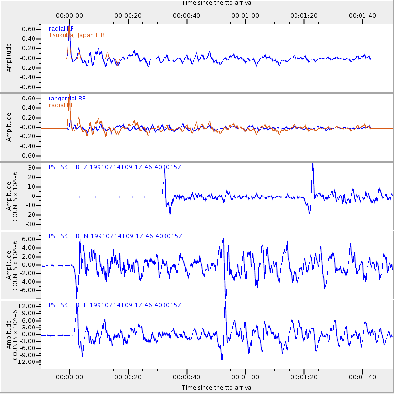
Signal To Noise
| Channel | StoN | STA | LTA |
| PS:TSK: :BHN:19910714T09:17:46.403015Z | 21.483364 | 2.9628577E-6 | 1.3791404E-7 |
| PS:TSK: :BHE:19910714T09:17:46.403015Z | 36.66968 | 5.286271E-6 | 1.4415919E-7 |
| PS:TSK: :BHZ:19910714T09:17:46.403015Z | 76.147064 | 1.0859748E-5 | 1.4261545E-7 |
| Arrivals |
| Ps | 3.2 SECOND |
| PpPs | 9.3 SECOND |
| PsPs/PpSs | 12 SECOND |


