You are here: Home > Network List > PS - Pacific21 Stations List
> Station TSK Tsukuba, Japan > Earthquake Result Viewer
TSK Tsukuba, Japan - Earthquake Result Viewer

| Earthquake location: |
Off Coast Of Northern California |
| Earthquake latitude/longitude: |
41.6/-125.5 |
| Earthquake time(UTC): |
1991/08/17 (229) 22:17:12 GMT |
| Earthquake Depth: |
10 km |
| Earthquake Magnitude: |
6.2 MB, 7.1 MS, 6.8 ML |
| Earthquake Catalog/Contributor: |
WHDF/NEIC |
|
| Network: |
PS Pacific21 |
| Station: |
TSK Tsukuba, Japan |
| Lat/Lon: |
36.21 N/140.11 E |
| Elevation: |
350 m |
|
| Distance: |
70.0 deg |
| Az: |
300.868 deg |
| Baz: |
52.745 deg |
| Ray Param: |
0.055301636 |
| Estimated Moho Depth: |
45.0 km |
| Estimated Crust Vp/Vs: |
1.99 |
| Assumed Crust Vp: |
6.24 km/s |
| Estimated Crust Vs: |
3.132 km/s |
| Estimated Crust Poisson's Ratio: |
0.33 |
|
| Radial Match: |
91.22465 % |
| Radial Bump: |
355 |
| Transverse Match: |
77.8199 % |
| Transverse Bump: |
386 |
| SOD ConfigId: |
16938 |
| Insert Time: |
2010-02-27 03:49:03.818 +0000 |
| GWidth: |
2.5 |
| Max Bumps: |
400 |
| Tol: |
0.001 |
|
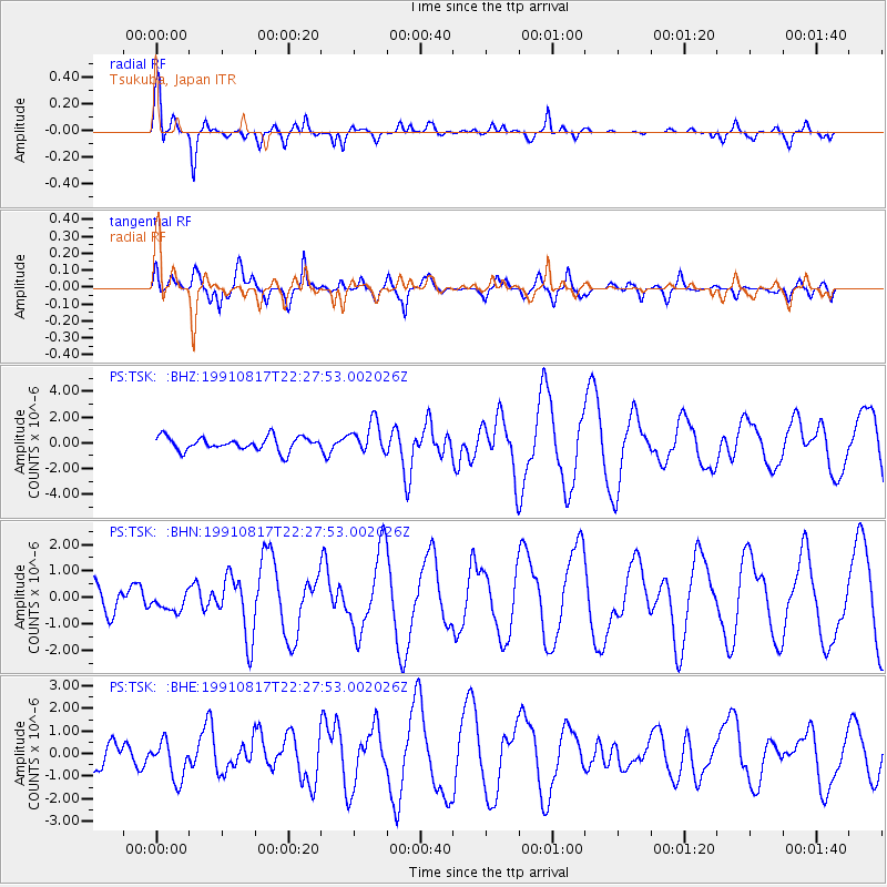
Signal To Noise
| Channel | StoN | STA | LTA |
| PS:TSK: :BHN:19910817T22:27:53.002026Z | 0.6614812 | 3.733645E-7 | 5.64437E-7 |
| PS:TSK: :BHE:19910817T22:27:53.002026Z | 1.7673786 | 8.5774377E-7 | 4.853198E-7 |
| PS:TSK: :BHZ:19910817T22:27:53.002026Z | 2.2678244 | 1.2123057E-6 | 5.3456773E-7 |
| Arrivals |
| Ps | 7.4 SECOND |
| PpPs | 21 SECOND |
| PsPs/PpSs | 28 SECOND |


