You are here: Home > Network List > PS - Pacific21 Stations List
> Station TSK Tsukuba, Japan > Earthquake Result Viewer
TSK Tsukuba, Japan - Earthquake Result Viewer
| Earthquake location: |
Andreanof Islands, Aleutian Is. |
| Earthquake latitude/longitude: |
52.5/-178.9 |
| Earthquake time(UTC): |
1992/03/13 (073) 16:01:06 GMT |
| Earthquake Depth: |
211 km |
| Earthquake Magnitude: |
6.0 MB, 6.3 UNKNOWN |
| Earthquake Catalog/Contributor: |
WHDF/NEIC |
|
| Network: |
PS Pacific21 |
| Station: |
TSK Tsukuba, Japan |
| Lat/Lon: |
36.21 N/140.11 E |
| Elevation: |
350 m |
|
| Distance: |
33.0 deg |
| Az: |
256.893 deg |
| Baz: |
47.44 deg |
| Ray Param: |
0.07772991 |
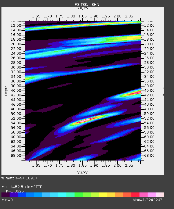
| Estimated Moho Depth: |
52.5 km |
| Estimated Crust Vp/Vs: |
1.86 |
| Assumed Crust Vp: |
6.24 km/s |
| Estimated Crust Vs: |
3.35 km/s |
| Estimated Crust Poisson's Ratio: |
0.30 |
|
| Radial Match: |
94.16917 % |
| Radial Bump: |
400 |
| Transverse Match: |
86.015015 % |
| Transverse Bump: |
400 |
| SOD ConfigId: |
16938 |
| Insert Time: |
2010-02-27 03:49:25.059 +0000 |
| GWidth: |
2.5 |
| Max Bumps: |
400 |
| Tol: |
0.001 |
|

Signal To Noise
| Channel | StoN | STA | LTA |
| PS:TSK: :BHN:19920313T16:06:50.450012Z | 10.398419 | 1.7497545E-6 | 1.6827119E-7 |
| PS:TSK: :BHE:19920313T16:06:50.450012Z | 14.925191 | 2.8937695E-6 | 1.9388492E-7 |
| PS:TSK: :BHZ:19920313T16:06:50.450012Z | 23.542988 | 5.127922E-6 | 2.17811E-7 |
| Arrivals |
| Ps | 7.8 SECOND |
| PpPs | 22 SECOND |
| PsPs/PpSs | 30 SECOND |


