You are here: Home > Network List > PS - Pacific21 Stations List
> Station TSK Tsukuba, Japan > Earthquake Result Viewer
TSK Tsukuba, Japan - Earthquake Result Viewer

| Earthquake location: |
Santa Cruz Islands |
| Earthquake latitude/longitude: |
-11.0/165.2 |
| Earthquake time(UTC): |
1992/05/27 (148) 05:13:41 GMT |
| Earthquake Depth: |
33 km |
| Earthquake Magnitude: |
6.3 MB, 7.0 MS, 7.3 UNKNOWN |
| Earthquake Catalog/Contributor: |
WHDF/NEIC |
|
| Network: |
PS Pacific21 |
| Station: |
TSK Tsukuba, Japan |
| Lat/Lon: |
36.21 N/140.11 E |
| Elevation: |
350 m |
|
| Distance: |
52.6 deg |
| Az: |
334.443 deg |
| Baz: |
148.419 deg |
| Ray Param: |
0.066590786 |
| Estimated Moho Depth: |
47.5 km |
| Estimated Crust Vp/Vs: |
1.74 |
| Assumed Crust Vp: |
6.24 km/s |
| Estimated Crust Vs: |
3.597 km/s |
| Estimated Crust Poisson's Ratio: |
0.25 |
|
| Radial Match: |
92.53879 % |
| Radial Bump: |
400 |
| Transverse Match: |
85.91087 % |
| Transverse Bump: |
400 |
| SOD ConfigId: |
16938 |
| Insert Time: |
2010-02-27 03:49:37.206 +0000 |
| GWidth: |
2.5 |
| Max Bumps: |
400 |
| Tol: |
0.001 |
|
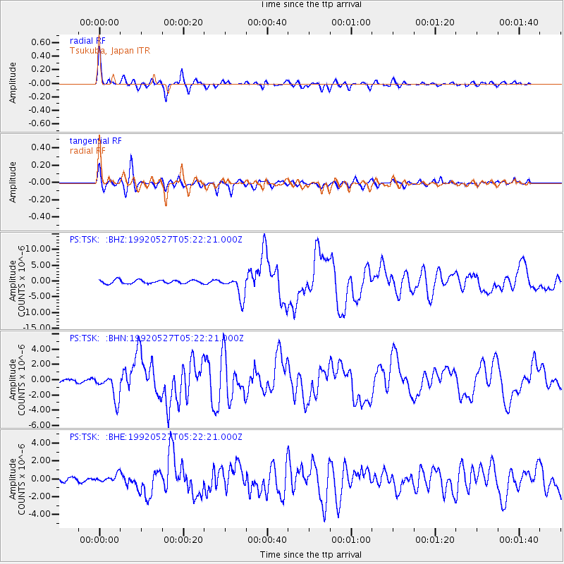
Signal To Noise
| Channel | StoN | STA | LTA |
| PS:TSK: :BHN:19920527T05:22:21.000Z | 10.937789 | 1.7517518E-6 | 1.6015595E-7 |
| PS:TSK: :BHE:19920527T05:22:21.000Z | 1.5059086 | 4.4599184E-7 | 2.961613E-7 |
| PS:TSK: :BHZ:19920527T05:22:21.000Z | 6.7115974 | 3.6723907E-6 | 5.471708E-7 |
| Arrivals |
| Ps | 5.9 SECOND |
| PpPs | 20 SECOND |
| PsPs/PpSs | 26 SECOND |


