You are here: Home > Network List > PS - Pacific21 Stations List
> Station TSK Tsukuba, Japan > Earthquake Result Viewer
TSK Tsukuba, Japan - Earthquake Result Viewer
| Earthquake location: |
Myanmar |
| Earthquake latitude/longitude: |
24.0/95.9 |
| Earthquake time(UTC): |
1992/06/15 (167) 02:48:56 GMT |
| Earthquake Depth: |
16 km |
| Earthquake Magnitude: |
5.7 MB, 6.3 MS |
| Earthquake Catalog/Contributor: |
WHDF/NEIC |
|
| Network: |
PS Pacific21 |
| Station: |
TSK Tsukuba, Japan |
| Lat/Lon: |
36.21 N/140.11 E |
| Elevation: |
350 m |
|
| Distance: |
39.8 deg |
| Az: |
61.704 deg |
| Baz: |
264.75 deg |
| Ray Param: |
0.074738756 |
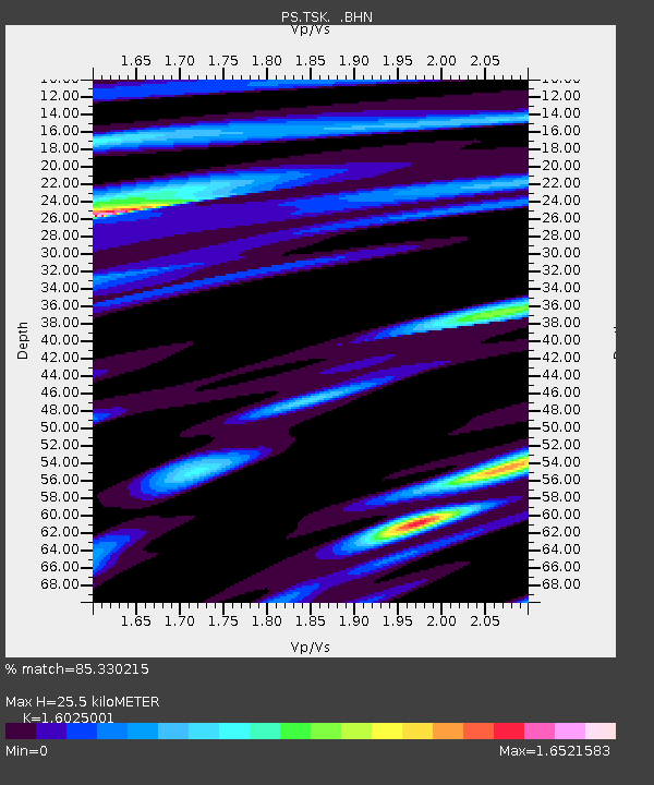
| Estimated Moho Depth: |
25.5 km |
| Estimated Crust Vp/Vs: |
1.60 |
| Assumed Crust Vp: |
6.24 km/s |
| Estimated Crust Vs: |
3.894 km/s |
| Estimated Crust Poisson's Ratio: |
0.18 |
|
| Radial Match: |
85.330215 % |
| Radial Bump: |
390 |
| Transverse Match: |
69.63138 % |
| Transverse Bump: |
400 |
| SOD ConfigId: |
16938 |
| Insert Time: |
2010-02-27 03:49:39.678 +0000 |
| GWidth: |
2.5 |
| Max Bumps: |
400 |
| Tol: |
0.001 |
|

Signal To Noise
| Channel | StoN | STA | LTA |
| PS:TSK: :BHN:19920615T02:55:57.748987Z | 1.4637308 | 1.512385E-7 | 1.03323984E-7 |
| PS:TSK: :BHE:19920615T02:55:57.748987Z | 2.5402813 | 2.5967645E-7 | 1.02223495E-7 |
| PS:TSK: :BHZ:19920615T02:55:57.748987Z | 3.28778 | 3.7627188E-7 | 1.14445584E-7 |
| Arrivals |
| Ps | 2.7 SECOND |
| PpPs | 9.9 SECOND |
| PsPs/PpSs | 13 SECOND |


