You are here: Home > Network List > TA - USArray Transportable Network (new EarthScope stations) Stations List
> Station 249A Camden, AL, USA > Earthquake Result Viewer
249A Camden, AL, USA - Earthquake Result Viewer
| Earthquake location: |
Central Peru |
| Earthquake latitude/longitude: |
-13.8/-72.3 |
| Earthquake time(UTC): |
2013/05/21 (141) 23:02:45 GMT |
| Earthquake Depth: |
92 km |
| Earthquake Magnitude: |
5.8 MW, 5.7 MB, 5.8 MW |
| Earthquake Catalog/Contributor: |
NEIC PDE/NEIC PDE-W |
|
| Network: |
TA USArray Transportable Network (new EarthScope stations) |
| Station: |
249A Camden, AL, USA |
| Lat/Lon: |
31.98 N/87.12 W |
| Elevation: |
66 m |
|
| Distance: |
47.7 deg |
| Az: |
342.856 deg |
| Baz: |
160.307 deg |
| Ray Param: |
0.06954762 |
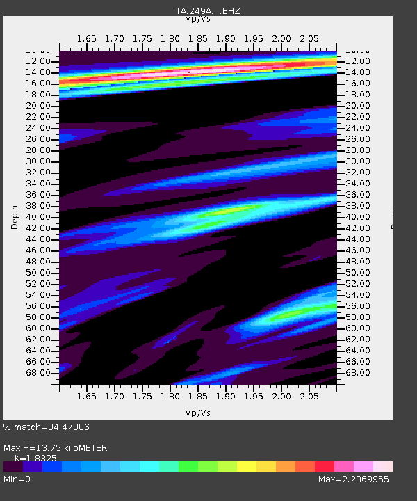
| Estimated Moho Depth: |
13.75 km |
| Estimated Crust Vp/Vs: |
1.83 |
| Assumed Crust Vp: |
6.187 km/s |
| Estimated Crust Vs: |
3.376 km/s |
| Estimated Crust Poisson's Ratio: |
0.29 |
|
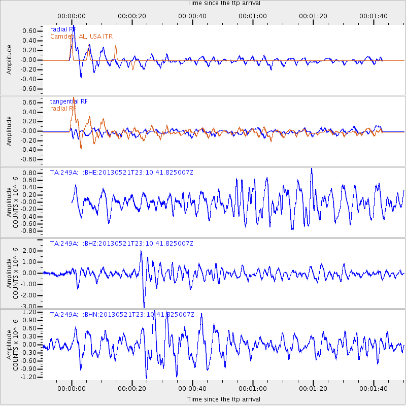
| Radial Match: |
84.47886 % |
| Radial Bump: |
400 |
| Transverse Match: |
50.10799 % |
| Transverse Bump: |
400 |
| SOD ConfigId: |
512894 |
| Insert Time: |
2013-09-14 15:19:29.736 +0000 |
| GWidth: |
2.5 |
| Max Bumps: |
400 |
| Tol: |
0.001 |
|
Signal To Noise
| Channel | StoN | STA | LTA |
| TA:249A: :BHZ:20130521T23:10:41.825007Z | 3.0210478 | 5.059856E-7 | 1.6748679E-7 |
| TA:249A: :BHN:20130521T23:10:41.825007Z | 2.5122387 | 3.9326176E-7 | 1.5653836E-7 |
| TA:249A: :BHE:20130521T23:10:41.825007Z | 0.69887847 | 1.4082359E-7 | 2.0149939E-7 |
| Arrivals |
| Ps | 2.0 SECOND |
| PpPs | 6.0 SECOND |
| PsPs/PpSs | 7.9 SECOND |


