You are here: Home > Network List > PS - Pacific21 Stations List
> Station TSK Tsukuba, Japan > Earthquake Result Viewer
TSK Tsukuba, Japan - Earthquake Result Viewer
| Earthquake location: |
Gulf Of Alaska |
| Earthquake latitude/longitude: |
57.6/-143.0 |
| Earthquake time(UTC): |
1992/08/07 (220) 18:19:19 GMT |
| Earthquake Depth: |
10 km |
| Earthquake Magnitude: |
6.3 MB, 6.5 MS, 6.5 ML |
| Earthquake Catalog/Contributor: |
WHDF/NEIC |
|
| Network: |
PS Pacific21 |
| Station: |
TSK Tsukuba, Japan |
| Lat/Lon: |
36.21 N/140.11 E |
| Elevation: |
350 m |
|
| Distance: |
53.5 deg |
| Az: |
281.591 deg |
| Baz: |
40.698 deg |
| Ray Param: |
0.06605518 |
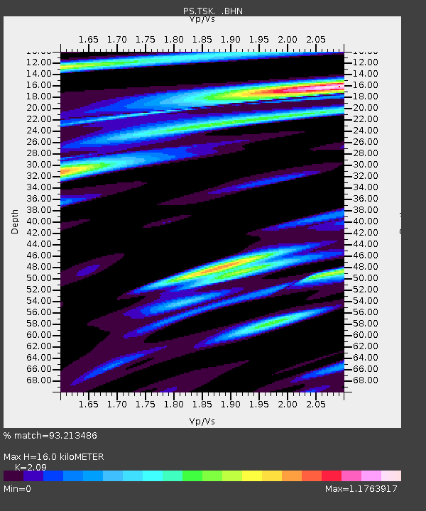
| Estimated Moho Depth: |
16.0 km |
| Estimated Crust Vp/Vs: |
2.09 |
| Assumed Crust Vp: |
6.24 km/s |
| Estimated Crust Vs: |
2.986 km/s |
| Estimated Crust Poisson's Ratio: |
0.35 |
|
| Radial Match: |
93.213486 % |
| Radial Bump: |
343 |
| Transverse Match: |
90.31726 % |
| Transverse Bump: |
400 |
| SOD ConfigId: |
16938 |
| Insert Time: |
2010-02-27 03:49:47.305 +0000 |
| GWidth: |
2.5 |
| Max Bumps: |
400 |
| Tol: |
0.001 |
|
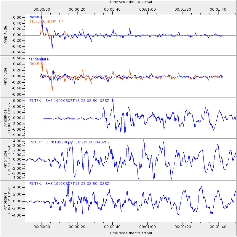
Signal To Noise
| Channel | StoN | STA | LTA |
| PS:TSK: :BHN:19920807T18:28:08.804028Z | 1.277209 | 2.478708E-7 | 1.9407223E-7 |
| PS:TSK: :BHE:19920807T18:28:08.804028Z | 1.957903 | 3.1674813E-7 | 1.6177927E-7 |
| PS:TSK: :BHZ:19920807T18:28:08.804028Z | 3.7957647 | 1.0145865E-6 | 2.6729435E-7 |
| Arrivals |
| Ps | 2.9 SECOND |
| PpPs | 7.6 SECOND |
| PsPs/PpSs | 11 SECOND |


